IMAGES TAKEN NEAR TO
Orleton Common, LUDLOW, SY8 4JG
Introduction
This page details the photographs taken nearby to Orleton Common, SY8 4JG by members of the Geograph project.
The Geograph project started in 2005 with the aim of publishing, organising and preserving representative images for every square kilometre of Great Britain, Ireland and the Isle of Man.

There are currently over 7.5m images from over14,400 individuals and you can help contribute to the project by visiting https://www.geograph.org.uk
Image Map
Images are licensed for reuse under creativecommons.org/licenses/by-sa/2.0
Notes
- Clicking on the map will re-center to the selected point.
- The higher the marker number, the further away the image location is from the centre of the postcode.
Image Listing (5 Images Found)
Images are licensed for reuse under creativecommons.org/licenses/by-sa/2.0
Image
Details
Distance
1
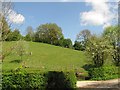
Field, Orleton Common
Steep, south facing grassland above Waterloo Lane.
Image: © Richard Webb
Taken: 4 May 2010
0.05 miles
2
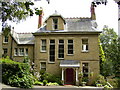
Prestigious house seen on the Mortimer Trail near Woodcock Hill
Image: © Phil Catterall
Taken: 13 Aug 2006
0.11 miles
3
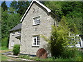
April's House, Waterloo Lane, near Richard's Castle
A large and impressive house in an isolated spot. Interesting circular saw blade
Image: © Jeremy Bolwell
Taken: 27 May 2011
0.17 miles
5
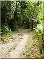
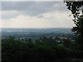
Roughish section of the Mortimer Trail
Image: © Phil Catterall
Taken: 13 Aug 2006
0.25 miles