IMAGES TAKEN NEAR TO
Orleton, LUDLOW, SY8 4HR
Introduction
This page details the photographs taken nearby to SY8 4HR by members of the Geograph project.
The Geograph project started in 2005 with the aim of publishing, organising and preserving representative images for every square kilometre of Great Britain, Ireland and the Isle of Man.

There are currently over 7.5m images from over14,400 individuals and you can help contribute to the project by visiting https://www.geograph.org.uk
Image Map (Loading...)


Getting Data...Please wait
Leaflet Map data © OpenStreetMap
Images are licensed for reuse under creativecommons.org/licenses/by-sa/2.0
Notes
- Clicking on the map will re-center to the selected point.
- The higher the marker number, the further away the image location is from the centre of the postcode.
Image Listing (235 Images Found)
Images are licensed for reuse under creativecommons.org/licenses/by-sa/2.0
Image
Details
Distance
1
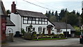
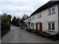
Timber-Framed House (Orleton)
A lovely looking timber-framed house at Orleton that has no grade listed status at all. Such a shame. The Methodist church is seen on the extreme left.
Image: © Fabian Musto
Taken: 28 Apr 2018
0.03 miles
2
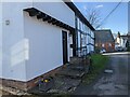
Orleton Post Office
View from outside The Boot.
Image: © Richard Webb
Taken: 23 Apr 2011
0.04 miles
3
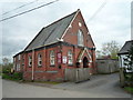
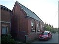
Orleton Methodist Church
One of the last pictures I took at my visit to Orleton, but decided to upload it here early with the others.
The Methodist church at Orleton is very unpopular and not many pictures of it have surfaced on the internet, however, I took this photo to make people realise there is a Methodist church at Orleton. To my thoughts, this looks alright, at first I thought it was a converted house, but then it seemed like I was wrong!
Image: © Fabian Musto
Taken: 28 Apr 2018
0.04 miles
4
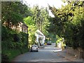
Tunnel Lane (Orleton)
Here is a section of Tunnel Lane at Orleton, viewed from the start of Church Lane. The Methodist church is seen on the left, whilst a nice looking timber-framed house is seen on the right.
Image: © Fabian Musto
Taken: 28 Apr 2018
0.04 miles
5
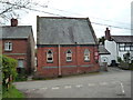
Orleton Methodist Church
Here is the Methodist church serving the village of Orleton from Tunnel Lane, and this was taken near Church Lane.
Image: © Fabian Musto
Taken: 5 Sep 2020
0.04 miles
6
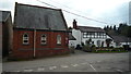
No. 1 Church Lane (Orleton)
This grade II listed building is near the road junction with Church Lane and Tunnel Lane, and the Methodist church is on Tunnel Lane. No. 1 Church Lane is a timber-framed building from the early C17, and this was extended at the turn of that century along with the mid C20.
Image: © Fabian Musto
Taken: 5 Mar 2022
0.04 miles
7
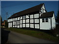
No. 1 Church Lane (Orleton)
One of the many fascinating timber-frame buildings in the village of Orleton is No. 1 Church Lane, which was built in the early 17th century. This was extended later on in the 17th century and the mid 20th century too
Image: © Fabian Musto
Taken: 20 Apr 2019
0.04 miles
8
Orleton Methodist Church
Side view of the Methodist church at Orleton.
Image: © Fabian Musto
Taken: 28 Apr 2018
0.04 miles
9
Post Office, Orleton
Orleton is called Alretvne in the Domesday Book meaning "enclosure of the Alders".
Image: © Bikeboy
Taken: 9 Apr 2014
0.05 miles
10
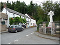
The war memorial and village post office, Orleton
One of the social centres of the village. The village is properly pronounced 'Orl-ton' rather than Or-let-ton, which I have also heard.
Image: © Jeremy Bolwell
Taken: 27 May 2011
0.05 miles