IMAGES TAKEN NEAR TO
Appleyard Close, LUDLOW, SY8 4HB
Introduction
This page details the photographs taken nearby to Appleyard Close, SY8 4HB by members of the Geograph project.
The Geograph project started in 2005 with the aim of publishing, organising and preserving representative images for every square kilometre of Great Britain, Ireland and the Isle of Man.

There are currently over 7.5m images from over14,400 individuals and you can help contribute to the project by visiting https://www.geograph.org.uk
Image Map (Loading...)


Getting Data...Please wait
Leaflet Map data © OpenStreetMap
Images are licensed for reuse under creativecommons.org/licenses/by-sa/2.0
Notes
- Clicking on the map will re-center to the selected point.
- The higher the marker number, the further away the image location is from the centre of the postcode.
Image Listing (236 Images Found)
Images are licensed for reuse under creativecommons.org/licenses/by-sa/2.0
Image
Details
Distance
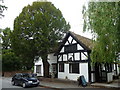
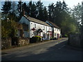
1
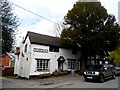
The Boot pub
Car with personalised number plates outside.
Image: © Bikeboy
Taken: 9 Apr 2014
0.02 miles
4
Ye Old House & Deacons Cottage (Orleton)
These buildings were built as a house originally in the 16th century, although it was partially rebuilt in the following century. This building is quite large if you see the back of it, as that was part of the early 20th century alterations.
Image: © Fabian Musto
Taken: 20 Apr 2019
0.05 miles
5
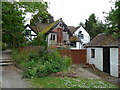
Old building at the rear of The Boot Inn, Orleton
This old structure caught my eye to one side of the beer garden of the Boot Inn.
Image: © Jeremy Bolwell
Taken: 27 May 2011
0.05 miles
6
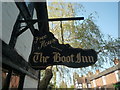
Sign at the Boot Inn (Orleton)
Interesting vintage sign that describes the Boot Inn well at Orleton.
Image: © Fabian Musto
Taken: 20 Apr 2019
0.05 miles
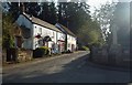
7
The Boot Inn, Orleton
I believe that this pub has changed hands, or management, a few times over recent years and months, like all too many pubs. But it seems well run, both wet side and food-wise, so let's hope it operates in profit and gets local support.
Image: © Jeremy Bolwell
Taken: 27 May 2011
0.05 miles
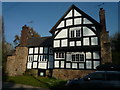
8
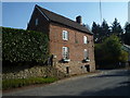
Brick House (Orleton)
Here is Brick House, which is placed by Kitchen Hill Road and was built in 1728. It was restored in the 1980's, and is now Grade II listed.
Image: © Fabian Musto
Taken: 20 Apr 2019
0.05 miles
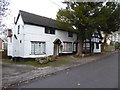
9
Orleton Post Office
The main post office at the village of Orleton is still open by today, and the old Post Office sign is still present on this building!
Image: © Fabian Musto
Taken: 20 Apr 2019
0.06 miles
10
Orleton Post Office & War Memorial
At the junction of Millbrook Way and Kitchen Hill Road are these two structures that make a good pair in the village of Orleton. The post office is seen on the left, which is still open by today, and the war memorial is seen on the right.
Image: © Fabian Musto
Taken: 20 Apr 2019
0.06 miles