IMAGES TAKEN NEAR TO
Woofferton, LUDLOW, SY8 4AL
Introduction
This page details the photographs taken nearby to SY8 4AL by members of the Geograph project.
The Geograph project started in 2005 with the aim of publishing, organising and preserving representative images for every square kilometre of Great Britain, Ireland and the Isle of Man.

There are currently over 7.5m images from over14,400 individuals and you can help contribute to the project by visiting https://www.geograph.org.uk
Image Map
Images are licensed for reuse under creativecommons.org/licenses/by-sa/2.0
Notes
- Clicking on the map will re-center to the selected point.
- The higher the marker number, the further away the image location is from the centre of the postcode.
Image Listing (36 Images Found)
Images are licensed for reuse under creativecommons.org/licenses/by-sa/2.0
Image
Details
Distance
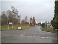
3
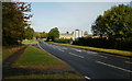
A49 View
The view near the junction of Station Road (B4362) on the A49 midway between Leominster and Ludlow.
Image: © Gordon Griffiths
Taken: 9 Mar 2015
0.02 miles
4
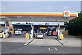
Filling station and shop, Woofferton
Built on former railway land at the crossroads by the Salway Arms. There was a garage at the Salway until around 1970.
Image: © Richard Webb
Taken: 23 Jul 2021
0.02 miles
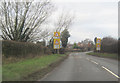
5

Daffodils next to Travelodge
On the corner of Station Road-B4362 and A49 Wooferton
Image: © PAUL FARMER
Taken: 7 Apr 2009
0.02 miles
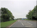
6
A49 heading north from Woofferton
Looking north from near the junction with the B4362 and A456 at Woofferton.
Image: © Jaggery
Taken: 10 Oct 2009
0.03 miles
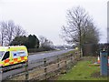
7
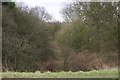
Disused Railway
I also believe this was the route of the Tenbury to Leominster canal.
Image: © Mr M Evison
Taken: 20 Jan 2008
0.03 miles
8
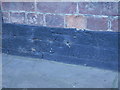
Nineteenth Century Benchmark on Salwey Arms
This Ordnance Survey bench mark was established in 1849 during the First primary levelling of England & Wales, and was levelled with a height of 242.9290 feet [74.0448 metres] above mean sea level (Liverpool datum). It was included on the Worcester to Aberystwyth levelling line. The surveyor's description was "No. 101. Bolt in front of the Silway Arms Inn, at junction of road to Ludlow ; 1.49 ft. above surface" (Public Abstract p.552).
Image: © Shantavira
Taken: 8 Apr 2017
0.03 miles
9
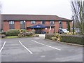
Woofferton Travelodge
The Motel off Station Road (B4362) and near the A49 midway between Leominster and Ludlow.
Image: © Gordon Griffiths
Taken: 9 Mar 2015
0.04 miles
10
Motel View
The view off Station Road (B4362) to the Woofferton Travelodge near the A49 midway between Leominster and Ludlow.
Image: © Gordon Griffiths
Taken: 8 Mar 2015
0.04 miles