IMAGES TAKEN NEAR TO
Clee Hill, LUDLOW, SY8 3PW
Introduction
This page details the photographs taken nearby to SY8 3PW by members of the Geograph project.
The Geograph project started in 2005 with the aim of publishing, organising and preserving representative images for every square kilometre of Great Britain, Ireland and the Isle of Man.

There are currently over 7.5m images from over14,400 individuals and you can help contribute to the project by visiting https://www.geograph.org.uk
Image Map
Images are licensed for reuse under creativecommons.org/licenses/by-sa/2.0
Notes
- Clicking on the map will re-center to the selected point.
- The higher the marker number, the further away the image location is from the centre of the postcode.
Image Listing (37 Images Found)
Images are licensed for reuse under creativecommons.org/licenses/by-sa/2.0
Image
Details
Distance
1
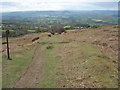
Lane at Titterstone
With the Benson's Brook valley just behind
Image: © Trevor Rickard
Taken: 10 Apr 2007
0.04 miles
2
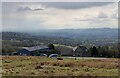
Old railway track at Clee Hill
Looking down the inclined plane which used to take minerals from the Clee Hill quarries. Old railway sign on the left. Directly in line is Ludlow just below the wooded High Vinnalls hill in the distance.
Image: © Trevor Rickard
Taken: 10 Apr 2007
0.08 miles
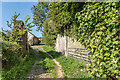
3
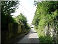
The abutments of Titterstone Incline
Crossing the lane between Bedlam and the quarry.
Image: © Christine Johnstone
Taken: 10 Aug 2011
0.09 miles
4
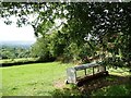
Animal feeder under a tree
In the field alongside the former Titterstone incline.
Image: © Christine Johnstone
Taken: 10 Aug 2011
0.09 miles
5
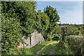
Titterstone Incline
Abutment of a bridge carrying the former Titterstone Incline over a track in Titterstone (marked on older maps as Bedlam). The incline, a narrow gauge cable hauled railway, linked the quarry on Titterstone Clee Hill with Bitterley Wharf on the Ludlow and Clee Hill Railway.
Image: © Ian Capper
Taken: 19 Sep 2020
0.11 miles
6
Titterstone Incline
Abutments of a bridge carrying the former Titterstone Incline over a track in Titterstone (marked on older maps as Bedlam). The incline, a narrow gauge cable hauled railway, linked the quarry on Titterstone Clee Hill with Bitterley Wharf on the Ludlow and Clee Hill Railway.
Image: © Ian Capper
Taken: 19 Sep 2020
0.11 miles
7
Titterstone Incline
Abutments of a bridge carrying the former Titterstone Incline over a track in Titterstone (marked on older maps as Bedlam). The incline, a narrow gauge cable hauled railway, linked the quarry on Titterstone Clee Hill with Bitterley Wharf on the Ludlow and Clee Hill Railway.
Image: © Ian Capper
Taken: 19 Sep 2020
0.11 miles
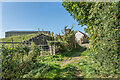
8
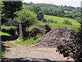
Disused railway incline at Bedlam
These abutments once held part of the mile-long Bitterley Incline, one of a pair of cable-railway inclines used for transporting stone from the Clee Hill quarries down to the railhead at Bitterley. The embankment of the steep incline can be seen on the right.
Image: © Trevor Rickard
Taken: 16 Jun 2010
0.12 miles
9
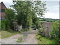
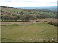
Bridleway to Cleehill
Dropping down to cross Benson's Brook.
Image: © Christine Johnstone
Taken: 10 Aug 2011
0.12 miles