IMAGES TAKEN NEAR TO
Bitterley, LUDLOW, SY8 3HJ
Introduction
This page details the photographs taken nearby to SY8 3HJ by members of the Geograph project.
The Geograph project started in 2005 with the aim of publishing, organising and preserving representative images for every square kilometre of Great Britain, Ireland and the Isle of Man.

There are currently over 7.5m images from over14,400 individuals and you can help contribute to the project by visiting https://www.geograph.org.uk
Image Map
Images are licensed for reuse under creativecommons.org/licenses/by-sa/2.0
Notes
- Clicking on the map will re-center to the selected point.
- The higher the marker number, the further away the image location is from the centre of the postcode.
Image Listing (18 Images Found)
Images are licensed for reuse under creativecommons.org/licenses/by-sa/2.0
Image
Details
Distance
1
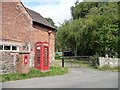
Village communications
Letter box and phone box near the centre of Bitterley.
Image: © Christine Johnstone
Taken: 10 Aug 2011
0.02 miles
3
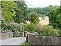
The eastern edge of Bitterley
Houses give way to fields.
Image: © Christine Johnstone
Taken: 10 Aug 2011
0.02 miles
4
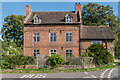
Bitterley House
Late 18th Century house in Bitterley. Grade II listed - see www.historicengland.org.uk/listing/the-list/list-entry/1383650.
Image: © Ian Capper
Taken: 19 Sep 2020
0.03 miles
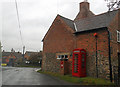
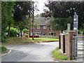
5
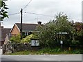
The centre of Bitterley
With a public water supply [marked Edward VII 1902], a parish noticeboard and a road junction.
Image: © Christine Johnstone
Taken: 10 Aug 2011
0.03 miles
6
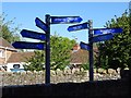
Distance signposts
Distance signposts at Bitterley School. A clever idea which give the children an idea of how far away cities and world renowned sites are.
Image: © Philip Halling
Taken: 20 Sep 2019
0.04 miles
7
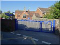
Bitterley School
Village primary school in Bitterley.
Image: © Philip Halling
Taken: 20 Sep 2019
0.04 miles
8
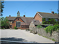
Bitterley School
Church of England primary school, originally set up by a legacy from Eton headmaster John Newborough in 1712.
Image: © Trevor Rickard
Taken: 16 Jun 2010
0.06 miles
9
Houses at the entrance to Orchard Lea
Seen down Clee Stanton Road, from the school gates.
Image: © Christine Johnstone
Taken: 10 Aug 2011
0.07 miles
10

Bitterley
Once municipal housing stock in the centre of the scattered village of Bitterley. There is still a school, the church is outside, possibly on the site of a former village, and there is no pub nor shop. Flag up for a particularly dismal World Cup showing.
Image: © Richard Webb
Taken: 21 Jun 2006
0.08 miles