IMAGES TAKEN NEAR TO
Hope Bagot, LUDLOW, SY8 3AG
Introduction
This page details the photographs taken nearby to SY8 3AG by members of the Geograph project.
The Geograph project started in 2005 with the aim of publishing, organising and preserving representative images for every square kilometre of Great Britain, Ireland and the Isle of Man.

There are currently over 7.5m images from over14,400 individuals and you can help contribute to the project by visiting https://www.geograph.org.uk
Image Map
Images are licensed for reuse under creativecommons.org/licenses/by-sa/2.0
Notes
- Clicking on the map will re-center to the selected point.
- The higher the marker number, the further away the image location is from the centre of the postcode.
Image Listing (12 Images Found)
Images are licensed for reuse under creativecommons.org/licenses/by-sa/2.0
Image
Details
Distance
1
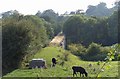
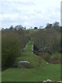
Elan Valley Aqueduct At Bennett's End
Part of the Elan Valley Aqueduct that feeds drinking water from Foel Tower Elan Valley to Frankley Reservoir in Birmingham
Image: © Mr M Evison
Taken: 25 Jul 2008
0.08 miles
2
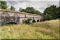
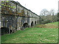
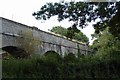
Bennettsend Bridge
Part of Bennettsend Bridge, a low bridge carrying the Elan Valley Aqueduct across the valley of Colly Brook southeast of Knowbury.
Image: © Ian Capper
Taken: 6 Aug 2020
0.15 miles
4
Bennettsend Bridge Aqueduct
Carrying drinking water from Elan Valley to Birmingham this aqueduct crosses a valley on the side of Cleehill to the southeast of Knowbury in Shropshire.
Image: © DI Wyman
Taken: 15 Apr 2008
0.20 miles
5
Bennettsend Bridge Aqueduct
The water pipeline from Elan Valley to Birmingham crosses this valley from west to east just to the south east of Knowbury near Cleehill in Shropshire.
Image: © DI Wyman
Taken: 15 Apr 2008
0.20 miles
6
Bennettsend Bridge Aqueduct
Carrying drinking water from Elan Valley to Birmingham this aqueduct crosses a valley on the side of Cleehill to the southeast of Knowbury in Shropshire.
Image: © DI Wyman
Taken: 15 Apr 2008
0.20 miles
7
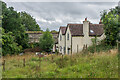
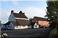
Brookfield and Bennettsend Bridge
House on Cumberley Lane. Beyond is part of Bennettsend Bridge, a low bridge carrying the Elan Valley Aqueduct across the valley of Colly Brook southeast of Knowbury.
Image: © Ian Capper
Taken: 6 Aug 2020
0.21 miles
8
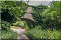
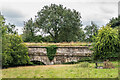
Bennettsend Bridge
Part of Bennettsend Bridge, a low bridge carrying the Elan Valley Aqueduct across the valley of Colly Brook southeast of Knowbury, here seen crossing Cumberley Lane.
Image: © Ian Capper
Taken: 6 Aug 2020
0.22 miles
9
Elan Valley Aqueduct At Bennett's End
Part of the Elan Valley Aqueduct that feeds drinking water from Foel Tower Elan Valley to Frankley Reservoir in Birmingham
Image: © Mr M Evison
Taken: 25 Jul 2008
0.22 miles
10
Bennettsend Bridge
Part of Bennettsend Bridge, a low bridge carrying the Elan Valley Aqueduct across the valley of Colly Brook southeast of Knowbury.
Image: © Ian Capper
Taken: 6 Aug 2020
0.23 miles