IMAGES TAKEN NEAR TO
New Street, LUDLOW, SY8 2NJ
Introduction
This page details the photographs taken nearby to New Street, SY8 2NJ by members of the Geograph project.
The Geograph project started in 2005 with the aim of publishing, organising and preserving representative images for every square kilometre of Great Britain, Ireland and the Isle of Man.

There are currently over 7.5m images from over14,400 individuals and you can help contribute to the project by visiting https://www.geograph.org.uk
Image Map
Images are licensed for reuse under creativecommons.org/licenses/by-sa/2.0
Notes
- Clicking on the map will re-center to the selected point.
- The higher the marker number, the further away the image location is from the centre of the postcode.
Image Listing (205 Images Found)
Images are licensed for reuse under creativecommons.org/licenses/by-sa/2.0
Image
Details
Distance
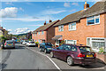
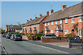
1
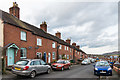
New Street
c.1970s housing in New Street. This section dates from the late 19th Century although the eastern side, seen here, had been left undeveloped. (See Image for the western side in this section, with its original Victorian terraced housing).
Image: © Ian Capper
Taken: 2 Aug 2020
0.01 miles
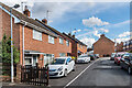
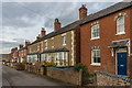
2
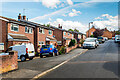
New Street
Working men's terraced housing built in the 1870s by local builder Benjamin Weale as part of the Victorian development of this area of Ludlow (East Hamlet or Sandpits) for which he was mainly responsible.
Image: © Ian Capper
Taken: 16 Feb 2018
0.02 miles
3
New Street
c.1970s housing in a northern extension of New Street.
Image: © Ian Capper
Taken: 2 Aug 2020
0.04 miles
4
33 & 35 Dodmore Lane
Pair of cottages on Dodmore Lane, marked on the 1886 25 inch map and so long predating the rest of the housing in the Sandpits estate, which date from the c.1950s.
Image: © Ian Capper
Taken: 28 Dec 2021
0.04 miles
5
New Street
c.1970s housing in New Street. This section dates from the late 19th Century although the eastern side, seen here, had been left undeveloped.
Image: © Ian Capper
Taken: 2 Aug 2020
0.04 miles
6
New Street
c.1970s housing in New Street. This section dates from the late 19th Century although the eastern side, seen here, had been left undeveloped.
Image: © Ian Capper
Taken: 2 Aug 2020
0.05 miles
7
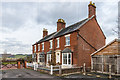
22-23 Castle View Terrace
Castle View Terrace was built in the 1870s on high land looking towards Ludlow Castle (as its name suggests) and Bringewood, as part of the Victorian development of this area of Ludlow (East Hamlet or Sandpits). The builder, Benjamin Weale, was responsible for much of this development. Castle View Terrace consisted mainly of a terrace of middle class villas (although this pair of houses are separate from the main terrace, they are of the same period) - compare the adjacent working men's housing in the adjacent New Street (see Image).
Image: © Ian Capper
Taken: 16 Feb 2018
0.05 miles
8
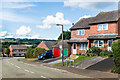
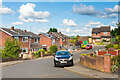
Hucklemarsh Road
c.1980s housing in Hucklemarsh Road.
Image: © Ian Capper
Taken: 2 Aug 2020
0.05 miles
9
Dodmore Lane
c.1950s housing in Dodmore Lane. Dodmore Lane itself is a much older route, starting with this section, before turning right along what is now Lacy Road (in the left background of this photo) and then turning into a path (see Image, Image and Image) which originally ended just beyond the current Ludlow bypass, but now truncated by that road.
Image: © Ian Capper
Taken: 20 Sep 2020
0.05 miles
10
Castle View Terrace
Castle View Terrace was built in the 1870s on high land looking towards Ludlow Castle (as its name suggests) and Bringewood, as part of the Victorian development of this area of Ludlow (East Hamlet or Sandpits). The builder, Benjamin Weale, was responsible for much of this development. Castle View Terrace consisted of a terrace of middle class villas - compare the adjacent working men's housing in the adjacent New Street (see Image).
Image: © Ian Capper
Taken: 16 Feb 2018
0.06 miles