IMAGES TAKEN NEAR TO
Downton Castle, LUDLOW, SY8 2LQ
Introduction
This page details the photographs taken nearby to SY8 2LQ by members of the Geograph project.
The Geograph project started in 2005 with the aim of publishing, organising and preserving representative images for every square kilometre of Great Britain, Ireland and the Isle of Man.

There are currently over 7.5m images from over14,400 individuals and you can help contribute to the project by visiting https://www.geograph.org.uk
Image Map
Images are licensed for reuse under creativecommons.org/licenses/by-sa/2.0
Notes
- Clicking on the map will re-center to the selected point.
- The higher the marker number, the further away the image location is from the centre of the postcode.
Image Listing (19 Images Found)
Images are licensed for reuse under creativecommons.org/licenses/by-sa/2.0
Image
Details
Distance
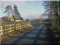
1
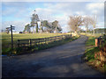
Entrance to Brakes Farm
View north-west to the farm buildings.
Image: © Trevor Rickard
Taken: 10 Dec 2008
0.03 miles
2
Brakes Farm
Farm buildings at Brakes Farm.
Image: © Philip Halling
Taken: 10 Dec 2021
0.05 miles
3
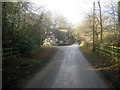
Lodge at Downton
Looking east along the lane to the substantial lodge at the entrance to Downton Castle.
Image: © Trevor Rickard
Taken: 10 Dec 2008
0.09 miles
4
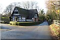
Lodge at entrance to Downton Castle
A Grade II listed building this lodge is in a mock-Tudor style which appeared to be popular at the time. The building dates from the 1860s. See: https://historicengland.org.uk/listing/the-list/list-entry/1082075?section=official-listing
Image: © Philip Halling
Taken: 10 Dec 2021
0.10 miles
5
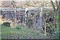
Bridge at entrance to Downton Castle
The bridge crosses a deep valley which Stone Brook flows through. The bridge just behind the lodge and was built as part of the major alterations to Downton Castle between 1860 and 1870. The bridge is Grade II listed, see: https://historicengland.org.uk/listing/the-list/list-entry/1081759?section=official-listing
Image: © Philip Halling
Taken: 10 Dec 2021
0.11 miles
6
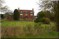
The Brakes
House on the lane leading to Downton on the Rock.
Image: © Ian Capper
Taken: 28 Mar 2010
0.12 miles
7
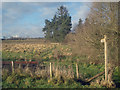
Public footpath at Downton
From the lane heading east to Brakes Farm.
Image: © Trevor Rickard
Taken: 10 Dec 2008
0.12 miles
8
The Brakes
Looking east along the lane at Downton with The Brakes in the trees on the left. Clee Hill in the distance.
Image: © Trevor Rickard
Taken: 10 Dec 2008
0.13 miles
9
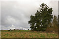
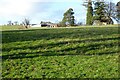
Shelter belt
A line of trees from the footpath from Forge Bridge to Brakes Farm.
Image: © Ian Capper
Taken: 28 Mar 2010
0.14 miles
10
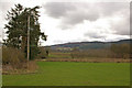
Towards Bringewood
Looking towards Bringewood (the wooded ridge in the background) from the footpath running for Brakes Farm to Forge Bridge.
Image: © Ian Capper
Taken: 28 Mar 2010
0.15 miles