IMAGES TAKEN NEAR TO
Leinthall Starkes, LUDLOW, SY8 2HR
Introduction
This page details the photographs taken nearby to SY8 2HR by members of the Geograph project.
The Geograph project started in 2005 with the aim of publishing, organising and preserving representative images for every square kilometre of Great Britain, Ireland and the Isle of Man.

There are currently over 7.5m images from over14,400 individuals and you can help contribute to the project by visiting https://www.geograph.org.uk
Image Map (5 Images)


Getting Data...Please wait
Leaflet Map data © OpenStreetMap
Images are licensed for reuse under creativecommons.org/licenses/by-sa/2.0
Notes
- Clicking on the map will re-center to the selected point.
- The higher the marker number, the further away the image location is from the centre of the postcode.
Image Listing (5 Images Found)
Images are licensed for reuse under creativecommons.org/licenses/by-sa/2.0
Image
Details
Distance
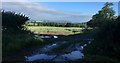
2
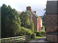
Farm buildings at Marlbrook Hall
Farm buildings at Marlbrook Hall near Elton and Leinthall Starkes.
Image: © Peter Evans
Taken: 21 Jun 2020
0.10 miles
3
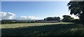
Newly ploughed arable land east of Marlbrook Hall
In the distance The Willows Farm is visible.
Image: © Stuart Logan
Taken: 22 Sep 2013
0.20 miles
5
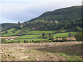
Wheat field near Marlbrook Hall
Wheat field near Marlbrook Hall, Elton, with a view towards Paytoe and Leintwardine
Image: © Peter Evans
Taken: 21 Jun 2020
0.24 miles