IMAGES TAKEN NEAR TO
Bowdler Close, LUDLOW, SY8 1UG
Introduction
This page details the photographs taken nearby to Bowdler Close, SY8 1UG by members of the Geograph project.
The Geograph project started in 2005 with the aim of publishing, organising and preserving representative images for every square kilometre of Great Britain, Ireland and the Isle of Man.

There are currently over 7.5m images from over14,400 individuals and you can help contribute to the project by visiting https://www.geograph.org.uk
Image Map (Loading...)


Getting Data...Please wait
Leaflet Map data © OpenStreetMap
Images are licensed for reuse under creativecommons.org/licenses/by-sa/2.0
Notes
- Clicking on the map will re-center to the selected point.
- The higher the marker number, the further away the image location is from the centre of the postcode.
Image Listing (63 Images Found)
Images are licensed for reuse under creativecommons.org/licenses/by-sa/2.0
Image
Details
Distance
1
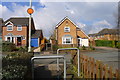
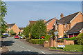
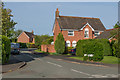
The Shropshire Way
Crossing Bowdler Close. Part of a modern housing estate on the east side of Ludlow
Image: © Tim Heaton
Taken: 25 Mar 2015
0.04 miles
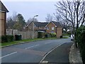
3
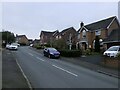
Shearman Road
1980s infilling of the bypass.
Image: © Richard Webb
Taken: 21 Dec 2021
0.07 miles
4
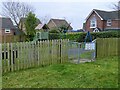
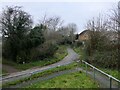
Darky Lane
Or Dark Lane on the maps - once rural and a useful short cut out of Sandpits, now blocked to motorised traffic. The path leads to the open space on Gallows Bank which I was pleasantly surprised to see had survived the house building.
Image: © Richard Webb
Taken: 21 Dec 2021
0.07 miles
5
Shearman Road
Late 1980s or early 1990s housing off Parys Road.
Image: © Ian Capper
Taken: 19 May 2016
0.08 miles
6
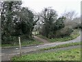
Darky Lane
Or Dark Lane on the maps - once rural and a useful short cut out of Sandpits, now blocked to motorised traffic.
Image: © Richard Webb
Taken: 21 Dec 2021
0.08 miles
7
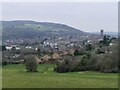
Ludlow from Gallows Bank
The green space here was part of a dairy farm before Charlton Rise was built on one of the fields in the 1970s. It is now surrounded by the expanding town.
Image: © Richard Webb
Taken: 21 Dec 2021
0.09 miles
8
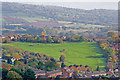
Gallows Bank
An area of grassland above Sheet Road, dedicated a Millennium Green in 1999. As its name suggests, it was originally the site of the town gallows.
Viewed from the tower of St Laurence's Church.
Image: © Ian Capper
Taken: 30 Oct 2010
0.09 miles
9
Blashfield Road
Late 1980s or early 1990s housing off Parys Road.
Image: © Ian Capper
Taken: 19 May 2016
0.09 miles
10
James Close
Infill housing inside the Ludlow bypass.
Image: © Richard Webb
Taken: 21 Dec 2021
0.10 miles