IMAGES TAKEN NEAR TO
Lower Galdeford, LUDLOW, SY8 1RT
Introduction
This page details the photographs taken nearby to Lower Galdeford, SY8 1RT by members of the Geograph project.
The Geograph project started in 2005 with the aim of publishing, organising and preserving representative images for every square kilometre of Great Britain, Ireland and the Isle of Man.

There are currently over 7.5m images from over14,400 individuals and you can help contribute to the project by visiting https://www.geograph.org.uk
Image Map (Loading...)


Getting Data...Please wait
Leaflet Map data © OpenStreetMap
Images are licensed for reuse under creativecommons.org/licenses/by-sa/2.0
Notes
- Clicking on the map will re-center to the selected point.
- The higher the marker number, the further away the image location is from the centre of the postcode.
Image Listing (633 Images Found)
Images are licensed for reuse under creativecommons.org/licenses/by-sa/2.0
Image
Details
Distance
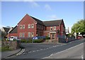
1
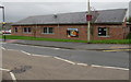
Shropshire Youth Ludlow
On the south side of Lower Galdeford, Shropshire Youth Ludlow is open five days a week (Mondays-Fridays) providing a range of activities such as homework groups, open youth club evenings for junior and senior youth age ranges and skills-based learning.
Image: © Jaggery
Taken: 9 Nov 2015
0.00 miles
2
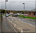
Zebra crossing, Lower Galdeford, Ludlow
With combined Belisha beacons and street lights.
Shropshire Youth Ludlow http://www.geograph.org.uk/photo/4734395 is on the right.
Image: © Jaggery
Taken: 9 Nov 2015
0.01 miles
3
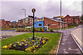
Alongside Lower Galdeford
A floral display in the grass verge between Smithfield car park and Lower Galedford, with Ludlow Police Station in the background.
Image: © Ian Capper
Taken: 10 Apr 2009
0.01 miles
4
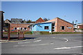
Shropshire Youth, Lower Galdeford
Information, activities, youth club and much more.
Image: © Pauline E
Taken: 7 Mar 2010
0.01 miles
5
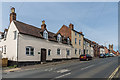
Lower Galdeford
Looking up Lower Galdeford with the tower of St Laurence's Church in the right background. The nearest building is nos. 65 and 66, a pair of 18th Century grade II listed cottages - see https://www.historicengland.org.uk/listing/the-list/list-entry/1290227. No 65 is named Tallow House and is adjacent to Chandlers Close, suggesting a local industry connected to the cattle market that once was once situated a short distance down Lower Galdeford.
Image: © Ian Capper
Taken: 19 May 2016
0.02 miles
6

Smithfield Inn
This shows the Smithfield Inn when it was closed and boarded up. Not long after this was taken, it was converted into a private house.
Image: © Jonathan Ormond
Taken: Unknown
0.02 miles
7
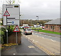
Direction sign, Lower Galdeford, Ludlow
Below the direction sign, a red-edged triangular sign warns of a skid risk.
Shropshire Youth Ludlow http://www.geograph.org.uk/photo/4734395 is on the right.
Image: © Jaggery
Taken: 9 Nov 2015
0.02 miles
8
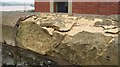
Frost damage
Frost damaged stonework outside Ludlow police station.
Image: © Richard Webb
Taken: 14 Feb 2009
0.02 miles
9
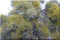
A mistletoe laden tree
A mistletoe laden tree beside a car park on Lower Galdeford in Ludlow.
Image: © Philip Halling
Taken: 15 Dec 2023
0.02 miles
10
Ludlow Police Station
On Lower Galdeford. http://www.westmercia.police.uk/contact-us/find-a-police-station/shropshire-police-station-opening-times.html
Image: © Mike Faherty
Taken: 14 May 2011
0.02 miles