IMAGES TAKEN NEAR TO
Marstons Terrace, LUDLOW, SY8 1QN
Introduction
This page details the photographs taken nearby to Marstons Terrace, SY8 1QN by members of the Geograph project.
The Geograph project started in 2005 with the aim of publishing, organising and preserving representative images for every square kilometre of Great Britain, Ireland and the Isle of Man.

There are currently over 7.5m images from over14,400 individuals and you can help contribute to the project by visiting https://www.geograph.org.uk
Image Map
Images are licensed for reuse under creativecommons.org/licenses/by-sa/2.0
Notes
- Clicking on the map will re-center to the selected point.
- The higher the marker number, the further away the image location is from the centre of the postcode.
Image Listing (1959 Images Found)
Images are licensed for reuse under creativecommons.org/licenses/by-sa/2.0
Image
Details
Distance
1
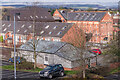
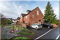
Marstons Terrace and Marstons Mill
Marstons Terrace is on the left. Marstons Mill, in the right background, was built in the 1890s by a prominent local firm of corn merchants and bakers in Ludlow. After falling into disuse, it was converted to provide accommodation and training for homeless young people in the Ludlow area, known as Ludlow Foyer, winning a Ludlow Civic Society award in 2000 for its conversion. Compare Image - note the addition of the Grain Loft in the left background. Viewed from Station Drive.
Image: © Ian Capper
Taken: 12 Mar 2022
0.01 miles
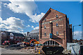
2
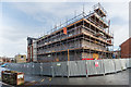
Grain Loft
New housing being built on the site of the former Harvest House on Portcullis Lane. The building, to be named Grain Loft, is to serve as an extension to the existing Marstons Mill building (part of which is just visible in the left background), now Ludlow Foyer, a housing project for young people aged 16-25. See Image for a photo of the previous building while being demolished.
Image: © Ian Capper
Taken: 10 Nov 2018
0.02 miles
3
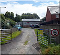
Army Cadet Centre in Ludlow
Set back from Portcullis Lane, near Ludlow railway station.
Image: © Jaggery
Taken: 22 Aug 2012
0.02 miles
4
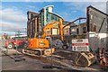
Demolition of Harvest House
Former office building in Portcullis Lane, seen here being demolished with a view to replacement with an 11 unit residential block, as an extension to the existing Marstons Mill building (in the background), now Ludlow Foyer, a housing project for young people aged 16-25. Part of the original building can be seen on the right of Image
Image: © Ian Capper
Taken: 1 Dec 2017
0.02 miles
5
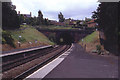
Looking South from Ludlow Station
Short tunnel from the end of the platform on Ludlow Station
Image: © Chris Heaton
Taken: 10 Aug 1993
0.02 miles
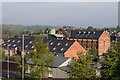
6
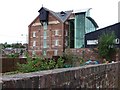
Ludlow Foyer
The former Marstons Mill, built in the 1890s by a prominent local firm of corn merchants and bakers in Ludlow. After falling into disuse, it was converted in around 2000 to provide accommodation and training for homeless young people in the Ludlow area, known as Ludlow Foyer.
Image: © Ian Capper
Taken: 9 Mar 2019
0.02 miles
7
Marstons Mill and Marstons Terrace
Marstons Mill, in the background, was built in the 1890s by a prominent local firm of corn merchants and bakers in Ludlow. After falling into disuse, it was converted to provide accommodation and training for homeless young people in the Ludlow area, known as Ludlow Foyer, winning a Ludlow Civic Society award in 2000 for its conversion.
Image: © Ian Capper
Taken: 5 May 2014
0.02 miles
8
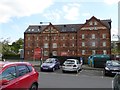
Former Marston's building (seed merchants), Ludlow
This building has now been converted into flats; but the Marston family intended their name to last!
Image: © David Smith
Taken: 22 Apr 2015
0.02 miles
9
4 - 7 The Snicketts
Housing off Portcullis Lane.
Image: © Ian Capper
Taken: 10 Nov 2018
0.03 miles
10
Spectacular staircase off Station Drive
Mill or warehouse converted into flats or offices.
Image: © Christine Johnstone
Taken: 12 Aug 2011
0.03 miles