IMAGES TAKEN NEAR TO
Whitcliffe Cottages, LUDLOW, SY8 1PN
Introduction
This page details the photographs taken nearby to Whitcliffe Cottages, SY8 1PN by members of the Geograph project.
The Geograph project started in 2005 with the aim of publishing, organising and preserving representative images for every square kilometre of Great Britain, Ireland and the Isle of Man.

There are currently over 7.5m images from over14,400 individuals and you can help contribute to the project by visiting https://www.geograph.org.uk
Image Map
Images are licensed for reuse under creativecommons.org/licenses/by-sa/2.0
Notes
- Clicking on the map will re-center to the selected point.
- The higher the marker number, the further away the image location is from the centre of the postcode.
Image Listing (904 Images Found)
Images are licensed for reuse under creativecommons.org/licenses/by-sa/2.0
Image
Details
Distance
1
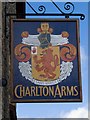
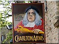
Charlton Arms sign from the south
The motto: Constant, or without changing. Curiously, the sign is different from the north.
Image: © Mike White
Taken: 8 Apr 2009
0.00 miles
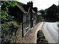
2
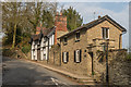
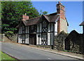
Whitcliffe Cottages
Grade II listed cottages on Whitcliffe Road.
The nearer one dates from the early 19th century while the one beyond, originally two houses, dates from the mid 19th century - for listing particulars see
www.historicengland.org.uk/listing/the-list/list-entry/1202821 and www.historicengland.org.uk/listing/the-list/list-entry/1202822 respectively.
The steps beyond are the footpath that leads over Whitcliffe and links with the Bread Walk to Dinham Bridge.
Image: © Ian Capper
Taken: 10 Apr 2015
0.00 miles
3
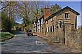
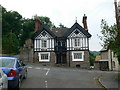
Whitcliffe Road
Seen here at its junction with Overton Road.
The cottages on the right are both grade II listed - the nearer one dates from the early 19th century while the one beyond, originally two houses, dates from the mid 19th century - for listing particulars see
www.historicengland.org.uk/listing/the-list/list-entry/1202821 and www.historicengland.org.uk/listing/the-list/list-entry/1202822 respectively.
The steps beyond are the footpath that leads over Whitcliffe and links with the Bread Walk to Dinham Bridge.
The Austin Seven (dating from 1929) was a chance arrival while the photo was being taken.
Image: © Ian Capper
Taken: 5 Apr 2009
0.00 miles
4
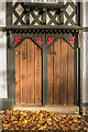
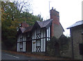
Door to Whitcliffe Lodge Cottage
Front door to Whitcliffe Lodge Cottage, with dragons in the corner. The building was originally divided into two cottages, hence the double front door. For a photo of the whole building, see Image
Image: © Ian Capper
Taken: 10 Nov 2018
0.00 miles
5
Charlton Arms sign from the north.
A very different and much more interesting sign on this side. The other side Image just has the coat of arms.
Image: © Mike White
Taken: 8 Apr 2009
0.01 miles
8
Cliff Villas, Ludford
Mid 19th century pseudo-timber framed houses opposite the church at Ludford.
Image: © Eirian Evans
Taken: 1 Jun 2008
0.01 miles
10
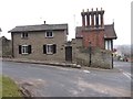
Old Toll House, 1 Whitcliffe Hill, Ludford
Toll House by the B4361, in the parish of Ludford, No. 1 Whitcliffe Cottages, Ludford.
Grade II listed.
List Entry Number: 1202821 https://historicengland.org.uk/listing/the-list/list-entry/1202821
Surveyed
Milestone Society National ID: SA.LUF
Image: © Milestone Society
Taken: Unknown
0.01 miles