IMAGES TAKEN NEAR TO
Steventon New Road, LUDLOW, SY8 1NA
Introduction
This page details the photographs taken nearby to Steventon New Road, SY8 1NA by members of the Geograph project.
The Geograph project started in 2005 with the aim of publishing, organising and preserving representative images for every square kilometre of Great Britain, Ireland and the Isle of Man.

There are currently over 7.5m images from over14,400 individuals and you can help contribute to the project by visiting https://www.geograph.org.uk
Image Map
Images are licensed for reuse under creativecommons.org/licenses/by-sa/2.0
Notes
- Clicking on the map will re-center to the selected point.
- The higher the marker number, the further away the image location is from the centre of the postcode.
Image Listing (81 Images Found)
Images are licensed for reuse under creativecommons.org/licenses/by-sa/2.0
Image
Details
Distance
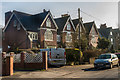
1
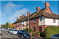
Steventon New Road
Victorian terrace in Steventon New Road (marked as Steventon Road on old maps).
Image: © Ian Capper
Taken: 4 Oct 2010
0.03 miles
2
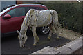
Wooden horse, Sheet Road
A lovely piece of artwork in a front drive.
Image: © Robert Eva
Taken: 4 Feb 2020
0.06 miles
3
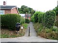
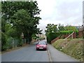
Path to Steventon New Road
Taken from Temeside.
Image: © Christine Johnstone
Taken: 10 Aug 2011
0.07 miles
4
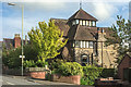
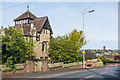
Kennet House
Kennet House on Sheet Road. It dates from 1872 and is reputed to have been built for a railway official who wanted to look down on the railway. It is grade II listed - see https://www.historicengland.org.uk/listing/the-list/list-entry/1212017.
Image: © Ian Capper
Taken: 22 May 2016
0.07 miles
5
49 - 53 Temeside
Row of Victorian villas on Temeside.
Image: © Ian Capper
Taken: 11 Mar 2016
0.07 miles
6
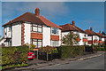
Steventon Crescent
1930s(?) housing in a short road connecting Steventon New Road and Temeside.
Image: © Ian Capper
Taken: 4 Oct 2010
0.07 miles
7
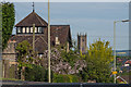
Kennet House and St Laurence's Church
A telephoto shot of Kennet House on Sheet Road, with the tower of St Laurence's Church in the background. Kennet House dates from 1872 and is reputed to have been built for a railway official who wanted to look down on the railway. It is grade II listed - see https://www.historicengland.org.uk/listing/the-list/list-entry/1212017.
Image: © Ian Capper
Taken: 19 May 2016
0.07 miles
8
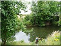
Angler on the Teme
Fishing at the foot of a flight of steps.
Image: © Christine Johnstone
Taken: 10 Aug 2011
0.07 miles
9
Kennet House
Kennet House on Sheet Road, with the tower of St Laurence's Church in the right background. Kennet House dates from 1872 and is reputed to have been built for a railway official who wanted to look down on the railway. It is grade II listed - see https://www.historicengland.org.uk/listing/the-list/list-entry/1212017.
Image: © Ian Capper
Taken: 19 May 2016
0.07 miles
10
Temeside, Ludlow
Looking towards the town centre.
Image: © Christine Johnstone
Taken: 10 Aug 2011
0.08 miles