IMAGES TAKEN NEAR TO
Julian Road, LUDLOW, SY8 1HB
Introduction
This page details the photographs taken nearby to Julian Road, SY8 1HB by members of the Geograph project.
The Geograph project started in 2005 with the aim of publishing, organising and preserving representative images for every square kilometre of Great Britain, Ireland and the Isle of Man.

There are currently over 7.5m images from over14,400 individuals and you can help contribute to the project by visiting https://www.geograph.org.uk
Image Map (Loading...)


Getting Data...Please wait
Leaflet Map data © OpenStreetMap
Images are licensed for reuse under creativecommons.org/licenses/by-sa/2.0
Notes
- Clicking on the map will re-center to the selected point.
- The higher the marker number, the further away the image location is from the centre of the postcode.
Image Listing (212 Images Found)
Images are licensed for reuse under creativecommons.org/licenses/by-sa/2.0
Image
Details
Distance
1
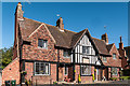
Elizabeth Massey Almshouses
1930 built almshouses in Julian Road, founded by local resident Elizabeth Massey primarily for Ludlow women aged over 55.
Image: © Ian Capper
Taken: 4 Oct 2010
0.00 miles
2
Elizabeth Massey Almshouses
1930 built almshouses in Julian Road, founded by local resident Elizabeth Massey primarily for Ludlow women aged over 55.
Image: © Ian Capper
Taken: 4 Oct 2010
0.00 miles
3
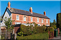
Julian Road
Victorian cottages in Julian Road.
Image: © Ian Capper
Taken: 4 Oct 2010
0.03 miles
4
51-53 Julian Road
Semidetached Victorian villas in Julian Road.
Image: © Ian Capper
Taken: 4 Oct 2010
0.03 miles
5

Bungalows, Poyner Road
One of several pockets of small houses for older people dotted around East Hamlet. They are all characterised by the presence of numerous bird feeders.
Image: © Richard Webb
Taken: 14 Jan 2022
0.05 miles
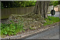
6
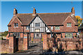
St Julian's Well
18th century well head in Livesey Road. The site originally stood inside an Augustian Friary foundede here in the 13th century, and is thought to be the source of Ludlow's first public water supply. Grade II listed - see www.historicengland.org.uk/listing/the-list/list-entry/1202883.
Image: © Ian Capper
Taken: 30 May 2013
0.07 miles
7
St Julian's Well
18th century well head in Livesey Road. The site originally stood inside an Augustian Friary foundede here in the 13th century, and is thought to be the source of Ludlow's first public water supply. Grade II listed - see www.historicengland.org.uk/listing/the-list/list-entry/1202883.
Image: © Ian Capper
Taken: 30 May 2013
0.07 miles
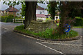
8
Livesey Road
Road first developed in the 1920s or so, although the route is much older. On the left is St Julian's Well (see Image and Image).
Image: © Ian Capper
Taken: 30 May 2013
0.07 miles
9

Bungalows, Poyner Road
A path in from Sandpits Road. Apparently I am prohibited, but as I did not have my bike with me, I doubt anyone noticed. (The houses are for older folk).
Image: © Richard Webb
Taken: 14 Jan 2022
0.07 miles
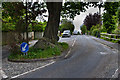
10

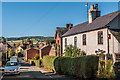
Sandpits Road
Looking towards some older houses which were once on the edge of town.
Image: © Richard Webb
Taken: 14 Jan 2022
0.08 miles