IMAGES TAKEN NEAR TO
Burway Close, Bromfield Road, LUDLOW, SY8 1GX
Introduction
This page details the photographs taken nearby to Burway Close, Bromfield Road, SY8 1GX by members of the Geograph project.
The Geograph project started in 2005 with the aim of publishing, organising and preserving representative images for every square kilometre of Great Britain, Ireland and the Isle of Man.

There are currently over 7.5m images from over14,400 individuals and you can help contribute to the project by visiting https://www.geograph.org.uk
Image Map
Images are licensed for reuse under creativecommons.org/licenses/by-sa/2.0
Notes
- Clicking on the map will re-center to the selected point.
- The higher the marker number, the further away the image location is from the centre of the postcode.
Image Listing (52 Images Found)
Images are licensed for reuse under creativecommons.org/licenses/by-sa/2.0
Image
Details
Distance
1
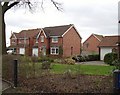
Healey Meters.
Well not quite. Houses on the site of the old Healey Meters factory.
Image: © Richard Webb
Taken: 2 Apr 2006
0.00 miles
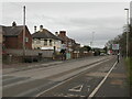
2
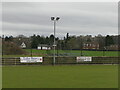
Burway Bowling Club and playing fields
Next to what were the playing fields of Ludlow Grammar and Ludlow High School. Some of the considerable acreage of recreational land ended up under houses in the 1980s. 11 year olds had to run from here to the school buildings in the town via Maryknoll and Whitcliffe Woods (c.6km) several times a term. Dreaded by most, I loved it.
The cricket pitch here has been used by Shropshire.
Image: © Richard Webb
Taken: 9 Feb 2022
0.03 miles
4
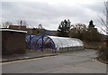
Hi-tec bike shed.
Smoker proof bike shed at Ludlow School.
Image: © Richard Webb
Taken: 2 Apr 2006
0.06 miles
5
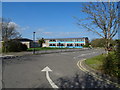
Ludlow Church of England School
On Bromfield Road.
Image: © JThomas
Taken: 28 Mar 2019
0.06 miles
6
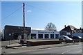
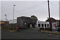
Majestic Wine Warehouse on Bromfield Road, Ludlow
Wine retailer Majestic Wine announced in March, 2019, it is to close stores and rename itself Naked Wine.
Image: © JThomas
Taken: 28 Mar 2019
0.06 miles
7
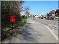
Bromfield Road, Ludlow
Showing position of Postbox No. SY8 142.
See Image] for postbox.
Image: © JThomas
Taken: 28 Mar 2019
0.07 miles
8
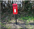
Elizabeth II postbox on Bromfield Road, Ludlow
Image: © JThomas
Taken: 28 Mar 2019
0.08 miles
9
Burway Road, Ludlow
The former A49, north of the town.
Image: © Richard Webb
Taken: 9 Feb 2022
0.08 miles
10
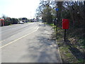
Bus stop on Bromfield Road, Ludlow
Showing position of Postbox No. SY8 142.
See Image] for postbox.
Image: © JThomas
Taken: 28 Mar 2019
0.08 miles