IMAGES TAKEN NEAR TO
Wheeler Close, LUDLOW, SY8 1GA
Introduction
This page details the photographs taken nearby to Wheeler Close, SY8 1GA by members of the Geograph project.
The Geograph project started in 2005 with the aim of publishing, organising and preserving representative images for every square kilometre of Great Britain, Ireland and the Isle of Man.

There are currently over 7.5m images from over14,400 individuals and you can help contribute to the project by visiting https://www.geograph.org.uk
Image Map (Loading...)


Getting Data...Please wait
Leaflet Map data © OpenStreetMap
Images are licensed for reuse under creativecommons.org/licenses/by-sa/2.0
Notes
- Clicking on the map will re-center to the selected point.
- The higher the marker number, the further away the image location is from the centre of the postcode.
Image Listing (86 Images Found)
Images are licensed for reuse under creativecommons.org/licenses/by-sa/2.0
Image
Details
Distance
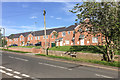
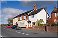
2
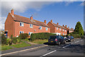
Riddings Road
Part of the council housing development of this part of Ludlow in the 1960s. Old maps show it to be along the route of Rock Lane, a track leading from Lower Galdeford to Rock Farm, only the lower part of which has retained the original name.
Image: © Ian Capper
Taken: 16 Oct 2011
0.04 miles
3
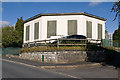
Water Tower
In Clee View. Old maps imply that it dates from the mid-1960s.
Image: © Ian Capper
Taken: 16 Oct 2011
0.05 miles
4
Riddings Road
1950s expansion of Ludlow along what was once known as Rock Lane. Riddings was a farm at the time. Land to the right of the picture was industrial, mainly a big depot and training facility for the Midlands Electricity Board. One of the current power companies still occupies some of the site.
Image: © Richard Webb
Taken: 21 Dec 2021
0.05 miles
5
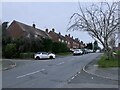
Riddings Road
Housing built by Wrekin Housing Trust in 2015 on the site of a former tax office (see Image).
Image: © Ian Capper
Taken: 22 May 2016
0.06 miles
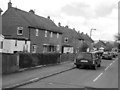
6
Prefab.
Something for the nation to be proud of! Cheap, rapidly built houses from the 1940's. A near bankrupt nation's answer to the housing shortage in a land ravaged by war and bombing. They were only temporary structures, but were so well built that some still survive. Many have been refurbished with cladding, but the renovation here has left a building close in appearance to the original. Clee View, Ludlow.
Image: © Richard Webb
Taken: 2 Apr 2006
0.06 miles
7
Clee View.
Housing estate in Ludlow, just north of Sandpits Road.
Image: © Richard Webb
Taken: 2 Apr 2006
0.06 miles
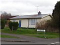
8
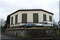
Former Tax Office
1960s office building in Riddings Road
Image: © Ian Capper
Taken: 16 Oct 2011
0.07 miles
9
Sandpits Road
Early 20th century maps call this road Sandpits Lane. These cottages stand out as different from the 1960s council house development of this part of Ludlow.
Image: © Ian Capper
Taken: 16 Oct 2011
0.08 miles
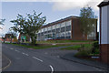
10
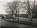
Ludlow Primary School
Opened in 1972 when St Lawrence (which I left that year) and Old Street merged. St Lawrence has since returned as a separate entity with a new school built on the Friar's Walk playing field.
Image: © Richard Webb
Taken: 14 Jan 2022
0.09 miles