IMAGES TAKEN NEAR TO
Bromfield Road, LUDLOW, SY8 1DN
Introduction
This page details the photographs taken nearby to Bromfield Road, SY8 1DN by members of the Geograph project.
The Geograph project started in 2005 with the aim of publishing, organising and preserving representative images for every square kilometre of Great Britain, Ireland and the Isle of Man.

There are currently over 7.5m images from over14,400 individuals and you can help contribute to the project by visiting https://www.geograph.org.uk
Image Map
Images are licensed for reuse under creativecommons.org/licenses/by-sa/2.0
Notes
- Clicking on the map will re-center to the selected point.
- The higher the marker number, the further away the image location is from the centre of the postcode.
Image Listing (357 Images Found)
Images are licensed for reuse under creativecommons.org/licenses/by-sa/2.0
Image
Details
Distance
1
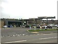
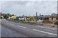
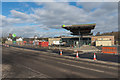
Filling station, Coronation Avenue
A relatively new building on what was agricultural land.
Image: © Richard Webb
Taken: 20 Dec 2021
0.01 miles
2
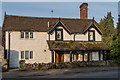
Burway Toll Cottage
Mid 19th century toll cottage on Bromfield Road. Grade II listed - see www.historicengland.org.uk/listing/the-list/list-entry/1282002.
Image: © Ian Capper
Taken: 5 May 2014
0.01 miles
3
Applegreen Petrol Station (Ludlow)
Recently completed petrol station on the outskirts of Ludlow.
Take a look at Ian Capper's photographs of the same structure being constructed: https://www.geograph.org.uk/stuff/list.php?title=Petrol+station%2C+Coronation+Avenue+-+under+construction&gridref=SO5075
Image: © Fabian Musto
Taken: 14 Apr 2018
0.02 miles
4
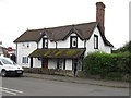
Old Toll House, Bromfield Road, Ludlow
Toll House by the B4361, in the parish of Ludlow, Tollgate (or Burway) Cottage, Bromfield Road.
Grade II listed.
List Entry Number: 1282002 https://historicengland.org.uk/listing/the-list/list-entry/1282002
Surveyed
Milestone Society National ID: SA.LUD02
Image: © Milestone Society
Taken: Unknown
0.02 miles
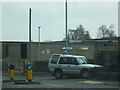
5
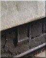
Ordnance Survey Flush Bracket (1122)
This OS Flush Bracket can be found on Burway Cottage. It marks a point 85.117m above mean sea level.
Image: © Adrian Dust
Taken: 25 Nov 2021
0.02 miles
6
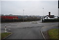
Zebra crossing over Coronation Avenue
Part of the B4361 in Ludlow.
Image: © DS Pugh
Taken: 23 Jun 2024
0.02 miles
7
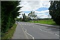
Junction of Burway Lane and Bromfield Rd
Image: © N Chadwick
Taken: 31 Dec 2010
0.02 miles
8
Petrol station, Coronation Avenue - under construction
A petrol station and convenience store under construction in Coronation Avenue.
Image: © Ian Capper
Taken: 2 Jan 2018
0.02 miles
9
Petrol station, Coronation Avenue - under construction
A petrol station and convenience store under construction in Coronation Avenue. Here the canopy is in place and the branding of the operator, Applegreen, has been applied - compare Image and Image
Image: © Ian Capper
Taken: 17 Feb 2018
0.02 miles
10
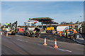
Petrol station, Coronation Avenue - under construction
A petrol station and convenience store under construction in Coronation Avenue. Here the canopy is in place and the branding of the operator, Applegreen, is being applied, with tarmac being laid on the entrance and pavement. Compare Image
Image: © Ian Capper
Taken: 16 Feb 2018
0.02 miles