IMAGES TAKEN NEAR TO
Newington Way, CRAVEN ARMS, SY7 9PS
Introduction
This page details the photographs taken nearby to Newington Way, SY7 9PS by members of the Geograph project.
The Geograph project started in 2005 with the aim of publishing, organising and preserving representative images for every square kilometre of Great Britain, Ireland and the Isle of Man.

There are currently over 7.5m images from over14,400 individuals and you can help contribute to the project by visiting https://www.geograph.org.uk
Image Map
Images are licensed for reuse under creativecommons.org/licenses/by-sa/2.0
Notes
- Clicking on the map will re-center to the selected point.
- The higher the marker number, the further away the image location is from the centre of the postcode.
Image Listing (205 Images Found)
Images are licensed for reuse under creativecommons.org/licenses/by-sa/2.0
Image
Details
Distance
1
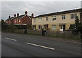
Housing variety, Shrewsbury Road, Craven Arms
On the east side of the A49 Shrewsbury Road.
Image: © Jaggery
Taken: 15 Nov 2019
0.05 miles
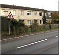
2
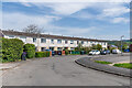
1 - 8 Newington Way
c.1980s terrace in a cul-de-sac off Shrewsbury Road.
Image: © Ian Capper
Taken: 4 May 2023
0.05 miles
3
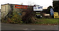
D & G Stone Services name sign, Craven Arms
Facing northbound traffic on the A49 Shrewsbury Road.
Image: © Jaggery
Taken: 15 Nov 2019
0.06 miles
4
Overnight lorry parking and public weighbridge direction sign, Craven Arms
On the west side of the A49 Shrewsbury Road.
Image: © Jaggery
Taken: 15 Nov 2019
0.06 miles
5
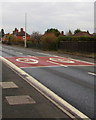
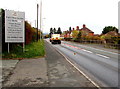
30 on the A49 Shrewsbury Road, Craven Arms
A reminder of the speed limit on this part of the A49.
Image: © Jaggery
Taken: 15 Nov 2019
0.06 miles
6
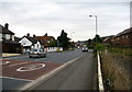
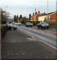
A49 Ludlow Road - Craven Arms, Shropshire
This view is looking south on the A49 Ludlow - Shrewsbury road at Craven Arms. There has been considerable new building in the town which has changed its appearance since days of childhood. The town was originally just two hamlets, Newington and Newton, and in the 19th century the building of a railway junction brought growth, the town being named after the 17th century Craven Arms Inn. The town has the headquarters of the Shropshire Hills AONB (Area of Outstanding Natural Beauty), the Secret Hills Discovery Centre, the Land of Lost Content museum - I found it a bit melancholic - and not far away to the south stands Stokesay Castle, an English Heritage property. Time taken 9.33 am BST (British Summer Time).
Image: © Martin Richard Phelan
Taken: 25 Oct 2008
0.06 miles
7
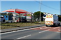
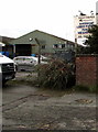
Craven Arms Hand Car Wash and Valeting Centre
Located on the west side of the A49 Shrewsbury Road.
Image: © Jaggery
Taken: 7 Sep 2012
0.06 miles
8
Warning sign - staggered crossroads, Shrewsbury Road, Craven Arms
Facing southbound traffic on the A49 Shrewsbury Road.
Image: © Jaggery
Taken: 15 Nov 2019
0.06 miles
9
Hand Car Wash direction sign, Craven Arms
The sign points the way to the hand car wash set back from the west side of the A49 Shrewsbury Road.
Image: © Jaggery
Taken: 15 Nov 2019
0.07 miles
10
North along the A49 Shrewsbury Road, Craven Arms
300 metres behind the camera, a sign https://www.geograph.org.uk/photo/6311425 shows 21 miles to Shrewsbury.
Image: © Jaggery
Taken: 15 Nov 2019
0.07 miles