IMAGES TAKEN NEAR TO
Church Street, CRAVEN ARMS, SY7 8JW
Introduction
This page details the photographs taken nearby to Church Street, SY7 8JW by members of the Geograph project.
The Geograph project started in 2005 with the aim of publishing, organising and preserving representative images for every square kilometre of Great Britain, Ireland and the Isle of Man.

There are currently over 7.5m images from over14,400 individuals and you can help contribute to the project by visiting https://www.geograph.org.uk
Image Map
Images are licensed for reuse under creativecommons.org/licenses/by-sa/2.0
Notes
- Clicking on the map will re-center to the selected point.
- The higher the marker number, the further away the image location is from the centre of the postcode.
Image Listing (609 Images Found)
Images are licensed for reuse under creativecommons.org/licenses/by-sa/2.0
Image
Details
Distance
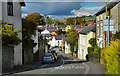
2
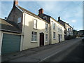
On Church Street in Clun
A lovely steep and winding street in this loveliest of Shropshire villages.
Image: © Jeremy Bolwell
Taken: 18 May 2019
0.01 miles
3
![Clun houses [29]](https://s3.geograph.org.uk/geophotos/06/98/49/6984999_c8c853f6_120x120.jpg)
Clun houses [29]
Number 10 Church Street was a pair of cottages, now one. Built in the early or mid 19th century and altered in the mid or late 19th century. Constructed of rendered brick under a slate roof. Listed, for group value, grade II, with details at: https://historicengland.org.uk/listing/the-list/list-entry/1054469
The small town of Clun is astride the River Clun in the Shropshire Hills Area of Outstanding Natural Beauty. It is located some 14 miles northwest of Ludlow and some 5½ miles north of Knighton. There is evidence of settlement in the Neolithic period but the town grew around the site of an Anglo-Saxon church. The Normans built a castle and a new town was laid out, the grid plan of which survives in this tranquil valley.
Image: © Michael Dibb
Taken: 2 Jun 2021
0.01 miles
4
![Clun houses [27]](https://s0.geograph.org.uk/geophotos/06/98/42/6984248_200c8657_120x120.jpg)
Clun houses [27]
Numbers 6 and 8 Church Street are a pair of houses dated 1711. The houses were heightened and refaced in the mid or late 19th century. Constructed of coursed rubble stone, roughcast rendered to the front, all under a slate roof. Listed, grade II, with details at: https://historicengland.org.uk/listing/the-list/list-entry/1175253
The small town of Clun is astride the River Clun in the Shropshire Hills Area of Outstanding Natural Beauty. It is located some 14 miles northwest of Ludlow and some 5½ miles north of Knighton. There is evidence of settlement in the Neolithic period but the town grew around the site of an Anglo-Saxon church. The Normans built a castle and a new town was laid out, the grid plan of which survives in this tranquil valley.
Image: © Michael Dibb
Taken: 2 Jun 2021
0.01 miles
5
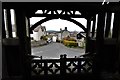
Clun, St George's Church: Church Street from the lych gate
Image: © Michael Garlick
Taken: 3 May 2018
0.01 miles
6
![Clun houses [30]](https://s0.geograph.org.uk/geophotos/06/98/50/6985000_59a086e0_120x120.jpg)
Clun houses [30]
Number 12 Church Street is an early or mid 19th century cottage. Constructed of rendered rubble stone under a slate roof. Listed, for group value, grade II, with details at: https://historicengland.org.uk/listing/the-list/list-entry/1295359
The small town of Clun is astride the River Clun in the Shropshire Hills Area of Outstanding Natural Beauty. It is located some 14 miles northwest of Ludlow and some 5½ miles north of Knighton. There is evidence of settlement in the Neolithic period but the town grew around the site of an Anglo-Saxon church. The Normans built a castle and a new town was laid out, the grid plan of which survives in this tranquil valley.
Image: © Michael Dibb
Taken: 2 Jun 2021
0.01 miles
7
![Clun houses [28]](https://s1.geograph.org.uk/geophotos/06/98/42/6984269_15353769_120x120.jpg)
Clun houses [28]
Castle Farmhouse, number 9 Church Street, was built in the 17th century and partly remodelled, rebuilt and extended in the mid 19th century. Probably timber framed, partly rebuilt and extended in coursed rubble stone, all under slate roof. Listed, grade II, with details at: https://historicengland.org.uk/listing/the-list/list-entry/1367255
The small town of Clun is astride the River Clun in the Shropshire Hills Area of Outstanding Natural Beauty. It is located some 14 miles northwest of Ludlow and some 5½ miles north of Knighton. There is evidence of settlement in the Neolithic period but the town grew around the site of an Anglo-Saxon church. The Normans built a castle and a new town was laid out, the grid plan of which survives in this tranquil valley.
Image: © Michael Dibb
Taken: 2 Jun 2021
0.02 miles
8
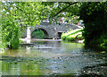
River Clun
The early summer level of the River Clun approaching the saddleback bridge at Clun.
Image: © J Scott
Taken: 16 Jun 2004
0.02 miles
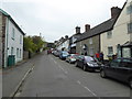
9
Church Street (Clun)
Georgian houses along the left side at Church Street in Clun.
Image: © Fabian Musto
Taken: 21 Feb 2019
0.02 miles
10
![Clun houses [25]](https://s3.geograph.org.uk/geophotos/06/98/42/6984231_52bc1765_120x120.jpg)
Clun houses [25]
Number 2 Church Street (seen here) and number 4 Church Street Image are a pair of, probably 17th century houses rebuilt in the mid or late 19th century. Possibly timber framed and rebuilt in coursed rubble stone, (number 2 rendered) under a slate roof. There is a carriageway to the left. Listed, grade II, with details at: https://historicengland.org.uk/listing/the-list/list-entry/1367256
The small town of Clun is astride the River Clun in the Shropshire Hills Area of Outstanding Natural Beauty. It is located some 14 miles northwest of Ludlow and some 5½ miles north of Knighton. There is evidence of settlement in the Neolithic period but the town grew around the site of an Anglo-Saxon church. The Normans built a castle and a new town was laid out, the grid plan of which survives in this tranquil valley.
Image: © Michael Dibb
Taken: 2 Jun 2021
0.02 miles