IMAGES TAKEN NEAR TO
SY7 7BU
Introduction
This page details the photographs taken nearby to SY7 7BU by members of the Geograph project.
The Geograph project started in 2005 with the aim of publishing, organising and preserving representative images for every square kilometre of Great Britain, Ireland and the Isle of Man.

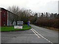
There are currently over 7.5m images from over14,400 individuals and you can help contribute to the project by visiting https://www.geograph.org.uk
Image Map (Loading...)


Getting Data...Please wait
Leaflet Map data © OpenStreetMap
Images are licensed for reuse under creativecommons.org/licenses/by-sa/2.0
Notes
- Clicking on the map will re-center to the selected point.
- The higher the marker number, the further away the image location is from the centre of the postcode.
Image Listing (59 Images Found)
Images are licensed for reuse under creativecommons.org/licenses/by-sa/2.0
Image
Details
Distance
2
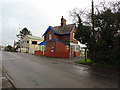
Signalman's cottage at Long Lane, Craven Arms
Image: © John Lucas
Taken: 6 Jan 2016
0.04 miles
3
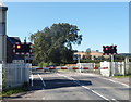
Barriers down and lights flashing, Long Lane level crossing, Craven Arms
The Long Lane level crossing is about 120 metres west of the A49 Shrewsbury Road.
The barriers block traffic from crossing the railway. A train will cross the road in a few seconds.
Craven Arms railway station is 550 metres to the south.
Image: © Jaggery
Taken: 7 Sep 2012
0.05 miles
4
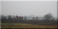
The view south from Craven Arms Crossing
The point on the right leads to two sidings (more in the past) which are now, inevitably, little used. The footbridge at Craven Arms station is visible in the distance.
Image: © John Lucas
Taken: 6 Jan 2016
0.05 miles
5
Craven Arms 'city limits'
A minor road leaving Craven Arms in the direction of Round Oak. The entrance to Craven Arms Business Park is on the left.
Image: © John Lucas
Taken: 6 Jan 2016
0.05 miles
6
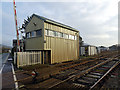
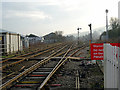
Craven Arms Long Lane Crossing signal box
The previous box here (not the original) was built in the 1930s and was of wooden construction. In 2000 the box was enlarged and clad as shown here, the wooden structure then being removed.
Image: © John Lucas
Taken: 6 Jan 2016
0.05 miles
7
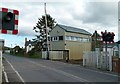
Craven Arms Crossing signal box
This is now the only signal box at Craven Arms, there previously having been boxes at the north and south ends of the station, and a small one controlling this level crossing on the near side of the track. With the simplification of track layout, particularly the junction for the Heart of Wales line, signalling was concentrated in this new box adjacent to the level crossing so that this could still be effectively monitored. It can hardly be considered an attractive design!
Image: © Alan Murray-Rust
Taken: 25 Apr 2016
0.05 miles
8
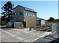
Craven Arms Crossing signalbox
The name on the signalbox is CRAVEN ARMS CROSSING. The identifier on a corner of the box is CA.
The signalbox is alongside, and controls, the Long Lane level crossing 120 metres west of the A49 Shrewsbury Road.
Image: © Jaggery
Taken: 7 Sep 2012
0.05 miles
9
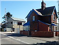
House and signalbox, Long Lane level crossing, Craven Arms
Viewed from the east side of the level crossing, 550 metres north of Craven Arms railway station.
Image: © Jaggery
Taken: 7 Sep 2012
0.05 miles
10
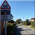
Stop when lights show, Long Lane, Craven Arms
The sign is about 50 metres from the Long Lane level crossing,
where the red lights have begun to flash and the barriers are about to descend. http://www.geograph.org.uk/photo/3343981
Image: © Jaggery
Taken: 7 Sep 2012
0.05 miles