IMAGES TAKEN NEAR TO
Hopton Castle, CRAVEN ARMS, SY7 0QF
Introduction
This page details the photographs taken nearby to SY7 0QF by members of the Geograph project.
The Geograph project started in 2005 with the aim of publishing, organising and preserving representative images for every square kilometre of Great Britain, Ireland and the Isle of Man.

There are currently over 7.5m images from over14,400 individuals and you can help contribute to the project by visiting https://www.geograph.org.uk
Image Map
Images are licensed for reuse under creativecommons.org/licenses/by-sa/2.0
Notes
- Clicking on the map will re-center to the selected point.
- The higher the marker number, the further away the image location is from the centre of the postcode.
Image Listing (103 Images Found)
Images are licensed for reuse under creativecommons.org/licenses/by-sa/2.0
Image
Details
Distance
1
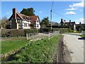
![Hopton Castle features [3]](https://s0.geograph.org.uk/geophotos/06/98/59/6985916_d8926e6c_120x120.jpg)
Hopton Castle features [3]
This utilitarian bridge carries the minor road over the unnamed stream.
Hopton Castle is a small village in the south of Shropshire near the boundaries of Wales and Herefordshire. It lies some 6 miles northeast of Knighton and some 3½ miles northwest of Leintwardine. Its main feature is the ruins of a castle.
Image: © Michael Dibb
Taken: 3 Jun 2021
0.02 miles
2
Timber-framed cottage
Timber-framed cottage in Hopton Castle.
Image: © Philip Halling
Taken: 14 Mar 2022
0.03 miles
3
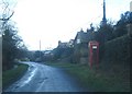
Telephone box at Hopton Castle
View westwards along the village lane. All of the boxes in this area are the traditional red ones - in keeping with this beautiful countryside.
Image: © Trevor Rickard
Taken: 9 Jan 2008
0.03 miles
4

Scene in Hopton Castle village
Standing on the footbridge over the brook here.
Image: © Jeremy Bolwell
Taken: 23 Feb 2019
0.04 miles
5
![Hopton Castle houses [6]](https://s3.geograph.org.uk/geophotos/06/98/59/6985915_2884f051_120x120.jpg)
Hopton Castle houses [6]
Numbers 6, 7 and 8 Hopton Castle were originally one farmhouse. Later divided into two dwellings, then reinstated into one house now seemingly two properties again. Built in the late 15th century as an open hall house, partly remodelled in the 17th century. Extended in the mid or late 19th century with later additions and alterations. Timber framed, partly of cruck construction with rendered and painted brick infill, encased or rebuilt in coursed rubble stone to the front and sides, all under a tile roof. Many original internal features remain. Listed, grade II, with details at: https://historicengland.org.uk/listing/the-list/list-entry/1367046
Hopton Castle is a small village in the south of Shropshire near the boundaries of Wales and Herefordshire. It lies some 6 miles northeast of Knighton and some 3½ miles northwest of Leintwardine. Its main feature is the ruins of a castle.
Image: © Michael Dibb
Taken: 3 Jun 2021
0.04 miles
6
![Hopton Castle features [2]](https://s2.geograph.org.uk/geophotos/06/98/59/6985914_33c6b62a_120x120.jpg)
Hopton Castle features [2]
A K6 telephone box, designed in 1935 by Sir Giles Gilbert Scott. Listed, grade II, with details at: https://historicengland.org.uk/listing/the-list/list-entry/1244600
Hopton Castle is a small village in the south of Shropshire near the boundaries of Wales and Herefordshire. It lies some 6 miles northeast of Knighton and some 3½ miles northwest of Leintwardine. Its main feature is the ruins of a castle.
Image: © Michael Dibb
Taken: 3 Jun 2021
0.05 miles
7
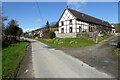
A barn conversion
A timber-framed barn conversion in the small village of Hopton Castle.
Image: © Philip Halling
Taken: 14 Mar 2022
0.06 miles
8

View to the church in Hopton Castle, Shropshire
Nice setting but a longish walk.
Image: © Jeremy Bolwell
Taken: 23 Feb 2019
0.06 miles
9
![Hopton Castle houses [5]](https://s1.geograph.org.uk/geophotos/06/98/59/6985913_3b69d065_120x120.jpg)
Hopton Castle houses [5]
Recently converted into a house, the barn was built in the early 17th century. Timber framed and weatherboarded on a rubble stone plinth under a tile roof. Listed, grade II, with details at: https://historicengland.org.uk/listing/the-list/list-entry/1054938
Hopton Castle is a small village in the south of Shropshire near the boundaries of Wales and Herefordshire. It lies some 6 miles northeast of Knighton and some 3½ miles northwest of Leintwardine. Its main feature is the ruins of a castle.
Image: © Michael Dibb
Taken: 3 Jun 2021
0.07 miles
10
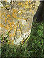
Ordnance Survey Cut Mark
This OS cut mark can be found on the south face of St Mary's Church. It marks a point 170.673m above mean sea level.
Image: © Adrian Dust
Taken: 20 Nov 2015
0.07 miles