IMAGES TAKEN NEAR TO
Cardington, CHURCH STRETTON, SY6 7JU
Introduction
This page details the photographs taken nearby to SY6 7JU by members of the Geograph project.
The Geograph project started in 2005 with the aim of publishing, organising and preserving representative images for every square kilometre of Great Britain, Ireland and the Isle of Man.

There are currently over 7.5m images from over14,400 individuals and you can help contribute to the project by visiting https://www.geograph.org.uk
Image Map
Images are licensed for reuse under creativecommons.org/licenses/by-sa/2.0
Notes
- Clicking on the map will re-center to the selected point.
- The higher the marker number, the further away the image location is from the centre of the postcode.
Image Listing (7 Images Found)
Images are licensed for reuse under creativecommons.org/licenses/by-sa/2.0
Image
Details
Distance
1
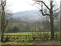
Shootrough
The railings suggest horse ownership here.
Image: © Richard Webb
Taken: 31 Mar 2007
0.07 miles
2
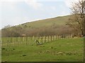
Shootrough
Fenced enclosure beneath the Lawley.
Image: © Richard Webb
Taken: 31 Mar 2007
0.13 miles
3
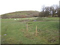
Pasture land at Shootrough
The distinctive shape of the Lawley looms in the background.
Image: © Jonathan Billinger
Taken: 6 Dec 2007
0.18 miles