IMAGES TAKEN NEAR TO
Sandford Avenue, CHURCH STRETTON, SY6 7AE
Introduction
This page details the photographs taken nearby to Sandford Avenue, SY6 7AE by members of the Geograph project.
The Geograph project started in 2005 with the aim of publishing, organising and preserving representative images for every square kilometre of Great Britain, Ireland and the Isle of Man.

There are currently over 7.5m images from over14,400 individuals and you can help contribute to the project by visiting https://www.geograph.org.uk
Image Map
Images are licensed for reuse under creativecommons.org/licenses/by-sa/2.0
Notes
- Clicking on the map will re-center to the selected point.
- The higher the marker number, the further away the image location is from the centre of the postcode.
Image Listing (44 Images Found)
Images are licensed for reuse under creativecommons.org/licenses/by-sa/2.0
Image
Details
Distance
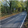
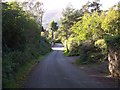
1
Unusual precision in Church Stretton
The sign alongside the B4371 Sandford Avenue shows that there is no footway for 477 yards.
Image: © Jaggery
Taken: 29 Oct 2013
0.03 miles
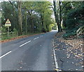
2
30 to 40 along Sandford Avenue, Church Stretton
The 40mph maximum speed sign is alongside the B4371 Sandford Avenue towards the eastern
edge of Church Stretton. This was formerly the start of the National Speed Limit.
Image: © Jaggery
Taken: 29 Oct 2013
0.05 miles
3
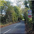
Walkers in road warning sign, Sandford Avenue, Church Stretton
There is no footway here for 477 yards. http://www.geograph.org.uk/photo/3875519
Image: © Jaggery
Taken: 29 Oct 2013
0.06 miles
4
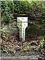
19th century milepost at Hazler
1 mile to the Market Hall in Church Stretton, 11 miles & 5 furlongs to the Wynnstay Arms in Much Wenlock, which is nowadays known as the Image The milepost was Grade II listed https://britishlistedbuildings.co.uk/101383301-milepost-at-ngr-so-4678-9333-church-stretton#.YYvc_mDP02w & https://historicengland.org.uk/listing/the-list/list-entry/1383301 in 2000
Image: © Richard Law
Taken: 2 Jul 2011
0.06 miles
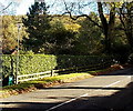
6
White House Gardens, Church Stretton
Viewed from the B4371 Sandford Avenue.
Image: © Jaggery
Taken: 29 Oct 2013
0.10 miles
7
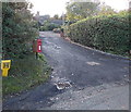
Yellow and red near Hazler Hill Farm, Church Stretton
A hydrant location marker and a postbox on a stand are on the corner of Hazler Road and the access road to Hazler Hill Farm.
Image: © Jaggery
Taken: 29 Oct 2013
0.10 miles
8
National Grid box in Church Stretton
The small green box on the left is alongside the B4371 Sandford Avenue.
Image: © Jaggery
Taken: 29 Oct 2013
0.12 miles
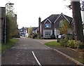
9
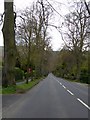
Sandford Road, Church Stretton
A straight, tree-lined road (B4371) on the east of the town
Image: © David Smith
Taken: 22 Apr 2015
0.13 miles
10
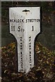
Old Milepost by the B4371, Sandford Avenue, Hazler Hill
Cast iron post by the B4371, in parish of CHURCH STRETTON (SOUTH SHROPSHIRE District), Sandford Avenue, Hazler Hill; opposite Hope Cottage, by the road, on North side of road. Wenlock post, erected by the Much Wenlock to Church Stretton turnpike trust in the 19th century.
Inscription reads:-
: WENLOCK / 11 5FU / TO THE WYNSTAY ARMS : : {motif} : : STRETTON / 1 / TO THE MARKET HALL :
Grade II listed. List Entry Number: 1383301
https://historicengland.org.uk/listing/the-list/list-entry/1383301
Milestone Society National ID: SA_CTMW01.
Image: © A Reade/J Higgins
Taken: 1 Feb 2008
0.13 miles