IMAGES TAKEN NEAR TO
Leebotwood, CHURCH STRETTON, SY6 6PA
Introduction
This page details the photographs taken nearby to SY6 6PA by members of the Geograph project.
The Geograph project started in 2005 with the aim of publishing, organising and preserving representative images for every square kilometre of Great Britain, Ireland and the Isle of Man.

There are currently over 7.5m images from over14,400 individuals and you can help contribute to the project by visiting https://www.geograph.org.uk
Image Map
Images are licensed for reuse under creativecommons.org/licenses/by-sa/2.0
Notes
- Clicking on the map will re-center to the selected point.
- The higher the marker number, the further away the image location is from the centre of the postcode.
Image Listing (10 Images Found)
Images are licensed for reuse under creativecommons.org/licenses/by-sa/2.0
Image
Details
Distance
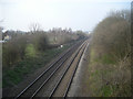
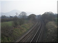
1
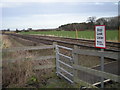
Shrewsbury and Hereford railway
The once threatened railway along the England/Wales border.
Image: © Richard Webb
Taken: 11 Oct 2017
0.05 miles
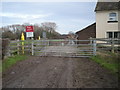
3
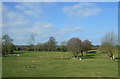
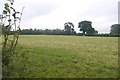
Sheep grazing near Fields Farm
North of Leebotwood.
Image: © JThomas
Taken: 28 Mar 2019
0.07 miles
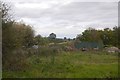
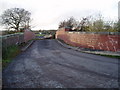
4
Narrow bridge 5m
A rare use of familiar units on the road. Very strongly displayed warning at a bridge over the Hereford and Shrewsbury railway.
Image: © Richard Webb
Taken: 11 Oct 2017
0.09 miles
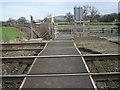
5
Railway bridge.
Bridge over the Shrewsbury to Hereford railway line just north of Leebotwood.
Image: © Eirian Evans
Taken: 27 Nov 2006
0.12 miles
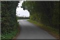
10
Field by Whitlea
Just off the A49 near Leebotwood.
Image: © Richard Webb
Taken: 2 Aug 2016
0.24 miles