IMAGES TAKEN NEAR TO
All Stretton, CHURCH STRETTON, SY6 6LJ
Introduction
This page details the photographs taken nearby to SY6 6LJ by members of the Geograph project.
The Geograph project started in 2005 with the aim of publishing, organising and preserving representative images for every square kilometre of Great Britain, Ireland and the Isle of Man.

There are currently over 7.5m images from over14,400 individuals and you can help contribute to the project by visiting https://www.geograph.org.uk
Image Map
Images are licensed for reuse under creativecommons.org/licenses/by-sa/2.0
Notes
- Clicking on the map will re-center to the selected point.
- The higher the marker number, the further away the image location is from the centre of the postcode.
Image Listing (34 Images Found)
Images are licensed for reuse under creativecommons.org/licenses/by-sa/2.0
Image
Details
Distance
2
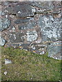
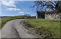
OS benchmark - Womerton
An OS cutmark on the south face of a small barn at Womerton; originally levelled at 255.724m above Ordnance Datum Newlyn. A number of the barns here have been converted into a small bunkhouse.
Image: © Richard Law
Taken: 4 Jul 2015
0.01 miles
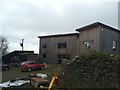
3
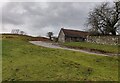
Womerton Farm
Farm at the head of Gogbatch.
Image: © Ian Capper
Taken: 20 Sep 2023
0.02 miles
4
Womerton Farm
Farm at the head of Gogbatch.
Image: © Ian Capper
Taken: 20 Sep 2023
0.02 miles
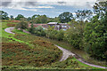
6
Womerton Farm at Womerton
Womerton is on the northeast edge of the Long Mynd.
Image: © Mat Fascione
Taken: 25 Feb 2023
0.02 miles
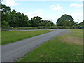
8
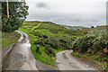
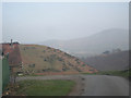
Lane junction
Lane junction at the head of Gogbatch.
Image: © Ian Capper
Taken: 20 Sep 2023
0.05 miles
9
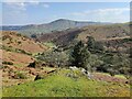
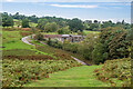
Gogbatch valley on the Long Mynd
On the northeastern edge of the Long Mynd.
Image: © Mat Fascione
Taken: 20 Mar 2022
0.06 miles