IMAGES TAKEN NEAR TO
Yeld Bank, Shrewsbury Road, CHURCH STRETTON, SY6 6EZ
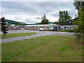
Introduction
This page details the photographs taken nearby to Yeld Bank, Shrewsbury Road, SY6 6EZ by members of the Geograph project.
The Geograph project started in 2005 with the aim of publishing, organising and preserving representative images for every square kilometre of Great Britain, Ireland and the Isle of Man.

There are currently over 7.5m images from over14,400 individuals and you can help contribute to the project by visiting https://www.geograph.org.uk
Image Map
Images are licensed for reuse under creativecommons.org/licenses/by-sa/2.0
Notes
- Clicking on the map will re-center to the selected point.
- The higher the marker number, the further away the image location is from the centre of the postcode.
Image Listing (28 Images Found)
Images are licensed for reuse under creativecommons.org/licenses/by-sa/2.0
Image
Details
Distance
1
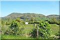
The View from Church Stretton
...from just outside the water bottling plant, actually. The mountain is Caer Caradoc.
Image: © Adrian Bailey
Taken: 15 May 2005
0.08 miles
2
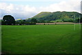
Springbank playing fields
Fields on the north side of Church Stretton. Caer Caradoc Hill is catching a bit of evening sunlight.
Image: © Bill Boaden
Taken: 18 Jun 2016
0.08 miles
3
Springbank playing fields
The town leisure facilities. Looking towards Caer Caradoc Hill in evening light.
Image: © Bill Boaden
Taken: 17 Jun 2016
0.09 miles
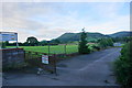
4
Princes Group depot
The home of Stretton Hills mineral water. This is where it is bottled.
Image: © Bill Boaden
Taken: 17 Jun 2016
0.09 miles
5
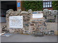
Stretton Hills water on tap
A free source of (otherwise expensive) water for those with a suitable container to put it in. A sign on the wall behind says words to the effect "We are happy with the quality & purity of the water from this source. If you put it in a dirty bottle, and get ill, don't blame us" - which is fair enough, in the circumstances.
Image: © Richard Law
Taken: 11 Aug 2010
0.11 miles
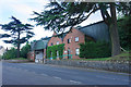
6
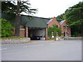
Stretton Hills Mineral Water Company
Originally founded in 1883, and bottling water from a pure spring source in the hills ever since. These days, it's owned and operated by Princes, who are maybe better known for their canned fruit, fish and the like. There's a tap built into the wall outside the front of the building, from which passing walkers and cyclists often refill their bottles.
Image: © Richard Law
Taken: 11 Aug 2010
0.11 miles
8
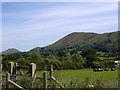
Farmland on the northern edge of Church Stretton
Looking towards the Shropshire Hills - Caer Caradoc
Image: © Keith Havercroft
Taken: Unknown
0.12 miles
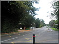
9
Church Stretton Secondary School
This school is a Technology College, and also serves as the start & finish points for the tough Long Mynd Hike walking event in early October each year www.longmyndhike.org.uk
Image: © Richard Law
Taken: 11 Aug 2010
0.13 miles
10
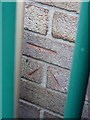
OS benchmark - Church Stretton school
An OS cutmark on the wall of the former school coke house; originally levelled at 189.653m above Ordnance Datum Newlyn. A clear & level photo is hard to come by, as the mark lies on the wrong side of a high fence, through which this picture is taken.
Image: © Richard Law
Taken: 13 Dec 2014
0.13 miles