IMAGES TAKEN NEAR TO
Blackmore, Westbury, SHREWSBURY, SY5 9RW
Introduction
This page details the photographs taken nearby to SY5 9RW by members of the Geograph project.
The Geograph project started in 2005 with the aim of publishing, organising and preserving representative images for every square kilometre of Great Britain, Ireland and the Isle of Man.

There are currently over 7.5m images from over14,400 individuals and you can help contribute to the project by visiting https://www.geograph.org.uk
Image Map (Loading...)


Getting Data...Please wait
Leaflet Map data © OpenStreetMap
Images are licensed for reuse under creativecommons.org/licenses/by-sa/2.0
Notes
- Clicking on the map will re-center to the selected point.
- The higher the marker number, the further away the image location is from the centre of the postcode.
Image Listing (8 Images Found)
Images are licensed for reuse under creativecommons.org/licenses/by-sa/2.0
Image
Details
Distance
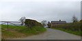
2
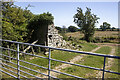
Track to Winnington Lodge Farm
Demolished vernacular farm building adjacent to track to Winnington Lodge Farm
Image: © P Gaskell
Taken: Unknown
0.13 miles
4
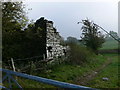
Ruin near Winnington Lodge Farm
At the northern end of Long Mountain.
Image: © Eirian Evans
Taken: 10 Oct 2007
0.15 miles
5
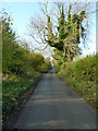
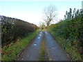
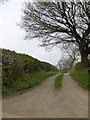
Ash trees and a country lane
Looking up the road that crosses Long Mountain, and follows the line of the Roman road between Montgomery and Shrewsbury (and eventually on to Wroxeter)
Image: © Richard Law
Taken: 11 Nov 2012
0.17 miles
7

High on Long Mountain
A small house, heavily adorned with PV panels, high on the ridge of Long Mountain.
Image: © Richard Law
Taken: 11 Nov 2012
0.19 miles
8
Road passing Plantation Holding
One of several minor roads branching off the Roman road on Long Mountain
Image: © David Smith
Taken: 24 Apr 2015
0.24 miles