IMAGES TAKEN NEAR TO
Forest, Westbury, SHREWSBURY, SY5 9RP
Introduction
This page details the photographs taken nearby to SY5 9RP by members of the Geograph project.
The Geograph project started in 2005 with the aim of publishing, organising and preserving representative images for every square kilometre of Great Britain, Ireland and the Isle of Man.

There are currently over 7.5m images from over14,400 individuals and you can help contribute to the project by visiting https://www.geograph.org.uk
Image Map (Loading...)


Getting Data...Please wait
Leaflet Map data © OpenStreetMap
Images are licensed for reuse under creativecommons.org/licenses/by-sa/2.0
Notes
- Clicking on the map will re-center to the selected point.
- The higher the marker number, the further away the image location is from the centre of the postcode.
Image Listing (5 Images Found)
Images are licensed for reuse under creativecommons.org/licenses/by-sa/2.0
Image
Details
Distance
1
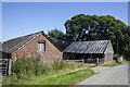
Forest Farm
Vernacular farm buildings at Forest Farm
Image: © P Gaskell
Taken: Unknown
0.02 miles
3
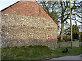
Barn gable at Forest Farm
The wallbox is an Edward VII job, seen in detail in Image
Image: © Richard Law
Taken: 11 Nov 2012
0.03 miles
4
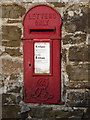
Edwardian wallbox at Forest Farm
Wallbox SY5 248 set into the gable of a barn.
Image: © Richard Law
Taken: 11 Nov 2012
0.03 miles