IMAGES TAKEN NEAR TO
Vennington, Westbury, SHREWSBURY, SY5 9RG
Introduction
This page details the photographs taken nearby to SY5 9RG by members of the Geograph project.
The Geograph project started in 2005 with the aim of publishing, organising and preserving representative images for every square kilometre of Great Britain, Ireland and the Isle of Man.

There are currently over 7.5m images from over14,400 individuals and you can help contribute to the project by visiting https://www.geograph.org.uk
Image Map (Loading...)


Getting Data...Please wait
Leaflet Map data © OpenStreetMap
Images are licensed for reuse under creativecommons.org/licenses/by-sa/2.0
Notes
- Clicking on the map will re-center to the selected point.
- The higher the marker number, the further away the image location is from the centre of the postcode.
Image Listing (16 Images Found)
Images are licensed for reuse under creativecommons.org/licenses/by-sa/2.0
Image
Details
Distance
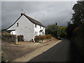
1
Approaching Vennington Farm from the north
Image: © Richard Law
Taken: 1 Apr 2013
0.01 miles
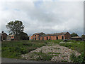
2
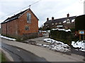
Middle Farm, Vennington
One of several farms based in the village - this one has a 4* self catering let attached.
Image: © Richard Law
Taken: 1 Apr 2013
0.03 miles
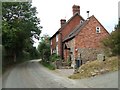
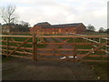
3
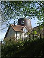
Entering Vennington from Westbury
Ones eye is caught by the distinctive house directly ahead with a gable facing the road
Image: © David Smith
Taken: 24 Apr 2015
0.05 miles
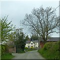
4
Vennington main (and only) road
A quiet but picturesque village on an unclassified road.
Image: © Anne
Taken: 27 Aug 2007
0.05 miles
8
Footpath across fields north of Vennington village
Image: © Richard Law
Taken: 1 Apr 2013
0.11 miles
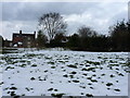
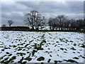
10
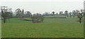
View over fields north of Vennington
Rolling Shropshire pasture land.
Image: © Jonathan Billinger
Taken: 3 Jan 2008
0.13 miles