IMAGES TAKEN NEAR TO
Ford, SHREWSBURY, SY5 9NE
Introduction
This page details the photographs taken nearby to SY5 9NE by members of the Geograph project.
The Geograph project started in 2005 with the aim of publishing, organising and preserving representative images for every square kilometre of Great Britain, Ireland and the Isle of Man.

There are currently over 7.5m images from over14,400 individuals and you can help contribute to the project by visiting https://www.geograph.org.uk
Image Map (Loading...)


Getting Data...Please wait
Leaflet Map data © OpenStreetMap
Images are licensed for reuse under creativecommons.org/licenses/by-sa/2.0
Notes
- Clicking on the map will re-center to the selected point.
- The higher the marker number, the further away the image location is from the centre of the postcode.
Image Listing (7 Images Found)
Images are licensed for reuse under creativecommons.org/licenses/by-sa/2.0
Image
Details
Distance
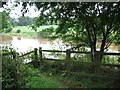
1
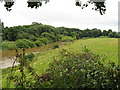
Severn viewpoint 4 - Shrawardine, Shropshire
This viewpoint, with a bench, stands above the Severn at the end of a public footpath from the village of Shrawardine - 'Shraden' to the locals - on the site of a now-disappeared bridge of the Shropshire & Montgomeryshire Railway. The site is on the edge of the extensive Nesscliffe Military Training Area, to which there is most emphatically no public access. Taken at 11.30 am BST (British Summer Time).
Image Image Image
Image: © Martin Richard Phelan
Taken: 17 Aug 2013
0.10 miles
2
Severn at Shrawardine
Site of Shropshire and Montgomeryshire railway bridge across the River Severn
see Image
Image: © Stephen Dewhirst
Taken: 24 Aug 2007
0.11 miles
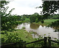
3
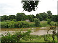
Severn viewpoint 3 - Shrawardine, Shropshire
Reached by a public footpath from Shrawardine - 'Shraden' to the locals - across the river from this viewpoint can be seen the opposite abutment of a Shropshire & Montgomeryshire Railway bridge which crossed the Severn at this point. The bridge was demolished in 1962, after serving a line which had a very chequered history. Taken at 11.28 am BST (British Summer Time).
Image: © Martin Richard Phelan
Taken: 17 Aug 2013
0.15 miles
4

Railway Bridge across River Severn (1954, now dismantled)
River crossing of the River Severn by the former Shropshire and Montgomeryshire Light Railway. Taken during RCTS (Railway Correspondence & Travel Society) on 25th April 1954. The bridge was long ago dismantled.
Image: © Ken Brockway
Taken: 25 Apr 1954
0.17 miles
5
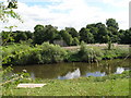
Remains of bridge at Shrawardine
Remains of the railway bridge at Shrawardine taken from the river.
Image: © Anthony Parkes
Taken: 5 Aug 2007
0.18 miles
6
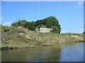
Severn viewpoint 1 - Shrawardine, Shropshire
A public footpath from Shrawardine - 'Shraden' to the locals - ends here at the site of a now-vanished railway bridge of the Shropshire & Montgomeryshire Railway. A bench here gives a pleasant spot for a break. Taken at 11.26 am BST (British Summer Time).
Image: © Martin Richard Phelan
Taken: 17 Aug 2013
0.21 miles
7
Severn viewpoint 2 - Shrawardine, Shropshire
A public footpath from Shrawardine - 'Shraden' to the locals - ends here at the site of a one time railway bridge over the Severn. The bridge, which was demolished in 1962, was on the route of the Shropshire & Montgomeryshire Railway, which had a chequered history in at times private and military ownership. Taken at 11.26 am BST (British Summer Time).
Image: © Martin Richard Phelan
Taken: 17 Aug 2013
0.23 miles