IMAGES TAKEN NEAR TO
Ford, SHREWSBURY, SY5 9ND
Introduction
This page details the photographs taken nearby to SY5 9ND by members of the Geograph project.
The Geograph project started in 2005 with the aim of publishing, organising and preserving representative images for every square kilometre of Great Britain, Ireland and the Isle of Man.

There are currently over 7.5m images from over14,400 individuals and you can help contribute to the project by visiting https://www.geograph.org.uk
Image Map (Loading...)


Getting Data...Please wait
Leaflet Map data © OpenStreetMap
Images are licensed for reuse under creativecommons.org/licenses/by-sa/2.0
Notes
- Clicking on the map will re-center to the selected point.
- The higher the marker number, the further away the image location is from the centre of the postcode.
Image Listing (6 Images Found)
Images are licensed for reuse under creativecommons.org/licenses/by-sa/2.0
Image
Details
Distance
2
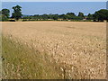
Wheatfield at Benthall
Looking north across the level country around the Severn from the B4393 between Ford and Alberbury. The building is at Benthall Cottages.
Image: © Derek Harper
Taken: 14 Jul 2006
0.13 miles
3
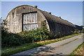
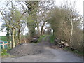
WWII Shropshire: AA Searchlight Site (1)
-
AA Searchlight: EDoB ID: e09911
In the undergrowth at Bentham Hall Farm behind this Romney hut, are the remains of Second World War Nissen huts that were apparently associated with the searchlight battery at Nib Heath. The Romney hut here is the sole survivor.
Image
Image: © Mike Searle
Taken: 15 Sep 2020
0.16 miles
4
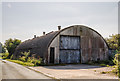
WWII Shropshire: AA Searchlight Site (2)
-
AA Searchlight: EDoB ID: e09911
Image
Image: © Mike Searle
Taken: 15 Sep 2020
0.16 miles