IMAGES TAKEN NEAR TO
Ford, SHREWSBURY, SY5 9NB
Introduction
This page details the photographs taken nearby to SY5 9NB by members of the Geograph project.
The Geograph project started in 2005 with the aim of publishing, organising and preserving representative images for every square kilometre of Great Britain, Ireland and the Isle of Man.

There are currently over 7.5m images from over14,400 individuals and you can help contribute to the project by visiting https://www.geograph.org.uk
Image Map (Loading...)


Getting Data...Please wait
Leaflet Map data © OpenStreetMap
Images are licensed for reuse under creativecommons.org/licenses/by-sa/2.0
Notes
- Clicking on the map will re-center to the selected point.
- The higher the marker number, the further away the image location is from the centre of the postcode.
Image Listing (8 Images Found)
Images are licensed for reuse under creativecommons.org/licenses/by-sa/2.0
Image
Details
Distance
1
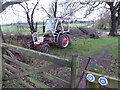
Old tractor beside the footpath
It's a David Brown 885 (fandom model details page https://tractors.fandom.com/wiki/David_Brown_885 here), dating from 1971 to 1980 apparently and a great British workhorse. What a gem. Love it!
Image: © Jeremy Bolwell
Taken: 30 Jan 2021
0.02 miles
2
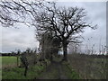
Old footpath between the fields
A nice route to walk on a bracing January Saturday afternoon.
Image: © Jeremy Bolwell
Taken: 30 Jan 2021
0.08 miles
4
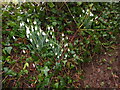
Snowdrops beside the footpath
Always a heartening sight!
Image: © Jeremy Bolwell
Taken: 30 Jan 2021
0.10 miles
5
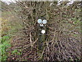
Waymarker discs on the footpath near Ford, Shropshire
I love a waymarker disc, me!
Image: © Jeremy Bolwell
Taken: 30 Jan 2021
0.13 miles
6
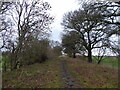
Disused railway line embankment and footpath near Ford, Shropshire
Part of the old Pots Line, a railway linking Shrewsbury with the Potteries area around Stoke-on-Trent, I believe. Also apparently used during World War II to carry munitions.
Now it carries a footpath and part of a local rambler's walk route. Which I am walking today. Very good it is too.
Image: © Jeremy Bolwell
Taken: 30 Jan 2021
0.15 miles
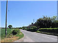
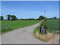
8
Road and footpath crossing
With a view to the snowy Breidden Hills beyond.
Image: © Jeremy Bolwell
Taken: 30 Jan 2021
0.24 miles