IMAGES TAKEN NEAR TO
Alberbury Road, SHREWSBURY, SY5 9NA
Introduction
This page details the photographs taken nearby to Alberbury Road, SY5 9NA by members of the Geograph project.
The Geograph project started in 2005 with the aim of publishing, organising and preserving representative images for every square kilometre of Great Britain, Ireland and the Isle of Man.

There are currently over 7.5m images from over14,400 individuals and you can help contribute to the project by visiting https://www.geograph.org.uk
Image Map (Loading...)


Getting Data...Please wait
Leaflet Map data © OpenStreetMap
Images are licensed for reuse under creativecommons.org/licenses/by-sa/2.0
Notes
- Clicking on the map will re-center to the selected point.
- The higher the marker number, the further away the image location is from the centre of the postcode.
Image Listing (15 Images Found)
Images are licensed for reuse under creativecommons.org/licenses/by-sa/2.0
Image
Details
Distance
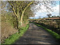
1
Road and footpath crossing
With a view to the snowy Breidden Hills beyond.
Image: © Jeremy Bolwell
Taken: 30 Jan 2021
0.06 miles
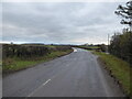
2
The Breidden Hills viewed in January from near Ford
Lovely hills that I have failed to visit for too long!
Image: © Jeremy Bolwell
Taken: 30 Jan 2021
0.07 miles
3
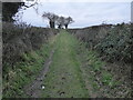
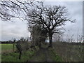
Green lane rising upslope in front of me
Someone has enjoyed the privilege of cantering their pony up here, the tracks remaining and visible here. What a joy it must be to canter up here on a pony or horse, its alert ears pricked ahead, its lovely head rising and falling and the rhythm of its canter a declaration of being alive, attuned and one; rider and ridden in perfect harmony.
A bond that the solo walker falls far short of. Ah well....
Image: © Jeremy Bolwell
Taken: 30 Jan 2021
0.07 miles
4

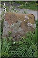
Old Wayside Cross by the B4393, Alberbury Road, Cardeston
Benthall Cross, old base by the bridleway off the B4393, in parish of Alberbury with Cardeston (Shrewsbury and Atcham District), Alberbury Road, Cardeston.
Grade II listed.
List Entry Number: 1055214 https://historicengland.org.uk/listing/the-list/list-entry/1055214
To be surveyed
Milestone Society National ID: SASH_ALB
Image: © J Haynes
Taken: 1 Jan 2013
0.07 miles
5
Old Wayside Cross by the A4393, Benthall Stone Farm, Alderbury
Benthall Cross, old base by the bridleway off B4393, in parish of Alberbury with Cardeston (Shrewsbury and Atcham District), Alberbury Road, Cardeston.
Grade II Listed. List Entry Number: 1055214
https://historicengland.org.uk/listing/the-list/list-entry/1055214
To be surveyed
Milestone Society National ID: SASH_ALB
Image: © A Reade
Taken: 28 Jul 2008
0.07 miles

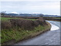
7
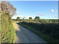
Track and Bridleway near Benthall Farm
Track approaching the B4393 road at Benthall Cross.
Image: © Jonathan Clitheroe
Taken: 21 Jul 2020
0.08 miles
8
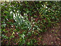
Snowdrops beside the footpath
Always a heartening sight!
Image: © Jeremy Bolwell
Taken: 30 Jan 2021
0.09 miles
9
Old footpath between the fields
A nice route to walk on a bracing January Saturday afternoon.
Image: © Jeremy Bolwell
Taken: 30 Jan 2021
0.11 miles