IMAGES TAKEN NEAR TO
Johnsons Bank, SHREWSBURY, SY5 9GX
Introduction
This page details the photographs taken nearby to Johnsons Bank, SY5 9GX by members of the Geograph project.
The Geograph project started in 2005 with the aim of publishing, organising and preserving representative images for every square kilometre of Great Britain, Ireland and the Isle of Man.

There are currently over 7.5m images from over14,400 individuals and you can help contribute to the project by visiting https://www.geograph.org.uk
Image Map (Loading...)


Getting Data...Please wait
Leaflet Map data © OpenStreetMap
Images are licensed for reuse under creativecommons.org/licenses/by-sa/2.0
Notes
- Clicking on the map will re-center to the selected point.
- The higher the marker number, the further away the image location is from the centre of the postcode.
Image Listing (5 Images Found)
Images are licensed for reuse under creativecommons.org/licenses/by-sa/2.0
Image
Details
Distance
1
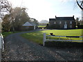
The South House near Nox, Shropshire
An elegant and understated detached property with wonderful outlook to its rear. Earls Hill visible here.
Image: © Jeremy Bolwell
Taken: 17 Nov 2011
0.07 miles
3
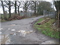
Gated track
Inspite of the gates this is a right-of-way.
Image: © Row17
Taken: 15 Jan 2008
0.22 miles