IMAGES TAKEN NEAR TO
Ford Heath, SHREWSBURY, SY5 9GH
Introduction
This page details the photographs taken nearby to SY5 9GH by members of the Geograph project.
The Geograph project started in 2005 with the aim of publishing, organising and preserving representative images for every square kilometre of Great Britain, Ireland and the Isle of Man.

There are currently over 7.5m images from over14,400 individuals and you can help contribute to the project by visiting https://www.geograph.org.uk
Image Map
Images are licensed for reuse under creativecommons.org/licenses/by-sa/2.0
Notes
- Clicking on the map will re-center to the selected point.
- The higher the marker number, the further away the image location is from the centre of the postcode.
Image Listing (6 Images Found)
Images are licensed for reuse under creativecommons.org/licenses/by-sa/2.0
Image
Details
Distance
1
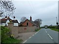
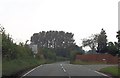
B4386 passing Cruckton House
A new wall onto the road, screening the house and its outbuildings and giving a safe entrance/exit
Image: © David Smith
Taken: 24 Apr 2015
0.02 miles
2
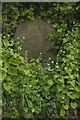
Old Milestone by the B4386, Nox Bank
Stone post (plate lost) by the B4386, in parish of Pontesbury (Shrewsbury and Atcham District), Nox Bank, near New House, on South side of road. Erected by the Shrewsbury to Welshpool turnpike trust in the 19th century.
Inscription once read:-
(Shrewsbury)
(5)
Shropshire HER.
HER Number (PRN): 21153 https://www.heritagegateway.org.uk/Gateway/Results_Single.aspx?uid=MSA23752&resourceID=1015
Milestone Society National ID: SA_SBMG05
Image: © A Reade/J Higgins
Taken: 28 Jul 2008
0.05 miles
6
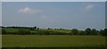
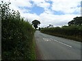
View north across the valley, east of Nox
Image: © Christopher Hilton
Taken: 9 Jun 2016
0.24 miles