IMAGES TAKEN NEAR TO
Winnington, Halfway House, SHREWSBURY, SY5 9FD
Introduction
This page details the photographs taken nearby to SY5 9FD by members of the Geograph project.
The Geograph project started in 2005 with the aim of publishing, organising and preserving representative images for every square kilometre of Great Britain, Ireland and the Isle of Man.

There are currently over 7.5m images from over14,400 individuals and you can help contribute to the project by visiting https://www.geograph.org.uk
Image Map
Images are licensed for reuse under creativecommons.org/licenses/by-sa/2.0
Notes
- Clicking on the map will re-center to the selected point.
- The higher the marker number, the further away the image location is from the centre of the postcode.
Image Listing (3 Images Found)
Images are licensed for reuse under creativecommons.org/licenses/by-sa/2.0
Image
Details
Distance
1
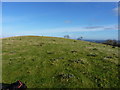
Nearly at the top of Hargrave Bank
A quick raid across the sheep fields, to visit the trig on Hargrave Bank. Daft Dog was securely attached to me.
Image: © Richard Law
Taken: 11 Nov 2012
0.17 miles
2
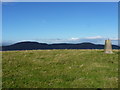
Towards the Breidden Hills from Hargrave Bank trig
Image: © Richard Law
Taken: 11 Nov 2012
0.18 miles
3
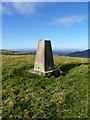
Hargrave Bank trig
Trig point with flush bracket S4752 on a fine sunny autumn morning.
Image: © Richard Law
Taken: 11 Nov 2012
0.19 miles