IMAGES TAKEN NEAR TO
Jubilee Mews, SHREWSBURY, SY5 9EZ
Introduction
This page details the photographs taken nearby to Jubilee Mews, SY5 9EZ by members of the Geograph project.
The Geograph project started in 2005 with the aim of publishing, organising and preserving representative images for every square kilometre of Great Britain, Ireland and the Isle of Man.

There are currently over 7.5m images from over14,400 individuals and you can help contribute to the project by visiting https://www.geograph.org.uk
Image Map (Loading...)


Getting Data...Please wait
Leaflet Map data © OpenStreetMap
Images are licensed for reuse under creativecommons.org/licenses/by-sa/2.0
Notes
- Clicking on the map will re-center to the selected point.
- The higher the marker number, the further away the image location is from the centre of the postcode.
Image Listing (26 Images Found)
Images are licensed for reuse under creativecommons.org/licenses/by-sa/2.0
Image
Details
Distance
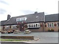
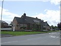
1
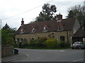
Former Public House?
Large building on the entrance to the village. Opposite the modern Lion Inn.
Image: © John M
Taken: 7 Jul 2007
0.01 miles
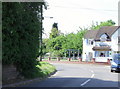
3
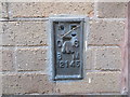
Ordnance Survey Flush Bracket 12145
This can be found on the wall of The Lion PH in Westbury.
For more detail see : http://www.bench-marks.org.uk/bm22771
Image: © Peter Wood
Taken: 7 Dec 2016
0.02 miles

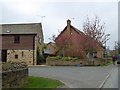
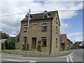
8
Courtyard housing
A development in the centre of Westbury village.
Image: © Jonathan Billinger
Taken: 3 Jan 2008
0.06 miles
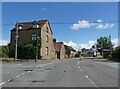
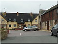
9
The Lion Inn
Public house on the main road into the village.
Image: © John M
Taken: 7 Jul 2007
0.07 miles