IMAGES TAKEN NEAR TO
Rowton, Halfway House, SHREWSBURY, SY5 9EN
Introduction
This page details the photographs taken nearby to SY5 9EN by members of the Geograph project.
The Geograph project started in 2005 with the aim of publishing, organising and preserving representative images for every square kilometre of Great Britain, Ireland and the Isle of Man.

There are currently over 7.5m images from over14,400 individuals and you can help contribute to the project by visiting https://www.geograph.org.uk
Image Map
Images are licensed for reuse under creativecommons.org/licenses/by-sa/2.0
Notes
- Clicking on the map will re-center to the selected point.
- The higher the marker number, the further away the image location is from the centre of the postcode.
Image Listing (13 Images Found)
Images are licensed for reuse under creativecommons.org/licenses/by-sa/2.0
Image
Details
Distance
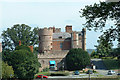
1
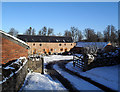
Rowton Barns
A traditional barnyard now converted into accommodation.
Image: © Des Blenkinsopp
Taken: 27 Nov 2010
0.04 miles
2
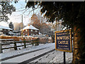
Houses near Rowton Castle
This driveway isn't shown on the map, but it's the main way in.
Image: © Des Blenkinsopp
Taken: 27 Nov 2010
0.07 miles
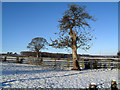
6
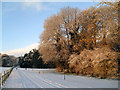
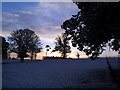
Trees in the Morning
Dawn light catches snowy trees in Rowton Castle park.
Image: © Des Blenkinsopp
Taken: 27 Nov 2010
0.13 miles
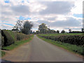
7
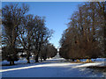
Avenue at Rowton Castle
This long avenue stretches away at the back of Rowton Castle.
Image: © Des Blenkinsopp
Taken: 28 Nov 2010
0.15 miles
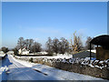
10
Sunrise at Rowton Park
First light over a snowy field at the front of Rowton Castle.
Image: © Des Blenkinsopp
Taken: 27 Nov 2010
0.17 miles