IMAGES TAKEN NEAR TO
Station Road, SHREWSBURY, SY5 9DB
Introduction
This page details the photographs taken nearby to Station Road, SY5 9DB by members of the Geograph project.
The Geograph project started in 2005 with the aim of publishing, organising and preserving representative images for every square kilometre of Great Britain, Ireland and the Isle of Man.

There are currently over 7.5m images from over14,400 individuals and you can help contribute to the project by visiting https://www.geograph.org.uk
Image Map
Images are licensed for reuse under creativecommons.org/licenses/by-sa/2.0
Notes
- Clicking on the map will re-center to the selected point.
- The higher the marker number, the further away the image location is from the centre of the postcode.
Image Listing (4 Images Found)
Images are licensed for reuse under creativecommons.org/licenses/by-sa/2.0
Image
Details
Distance
2
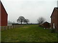
Gap between new houses
A public footpath heading south here across the fields to Upper Wigmore is possibly the reason why this plot remains undeveloped.
Image: © Jonathan Billinger
Taken: 3 Jan 2008
0.19 miles
3
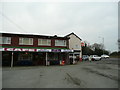
Shop, cafe and post office
A multi-business by the A458 at Wattlesborough. Sights like this are much more common in Ireland.
Image: © Jonathan Billinger
Taken: 3 Jan 2008
0.19 miles