IMAGES TAKEN NEAR TO
Caradoc View, SHREWSBURY, SY5 8ND
Introduction
This page details the photographs taken nearby to Caradoc View, SY5 8ND by members of the Geograph project.
The Geograph project started in 2005 with the aim of publishing, organising and preserving representative images for every square kilometre of Great Britain, Ireland and the Isle of Man.

There are currently over 7.5m images from over14,400 individuals and you can help contribute to the project by visiting https://www.geograph.org.uk
Image Map (Loading...)


Getting Data...Please wait
Leaflet Map data © OpenStreetMap
Images are licensed for reuse under creativecommons.org/licenses/by-sa/2.0
Notes
- Clicking on the map will re-center to the selected point.
- The higher the marker number, the further away the image location is from the centre of the postcode.
Image Listing (15 Images Found)
Images are licensed for reuse under creativecommons.org/licenses/by-sa/2.0
Image
Details
Distance
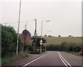
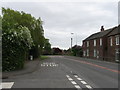
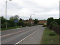
4
Hanwood Bank
Housing estate some distance from Hanwood. It is next to the trackbed of the Shropshire Railway, already marked as disused by the Ordnance Survey in 1901.
Image: © Richard Webb
Taken: 19 Mar 2018
0.09 miles
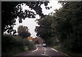
8
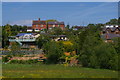
Hanwood Bank from the railway
Seen across the valley of the Rea Brook.
Image: © Christopher Hilton
Taken: 10 Jun 2015
0.13 miles