IMAGES TAKEN NEAR TO
Vine Close, SHREWSBURY, SY5 8LW
Introduction
This page details the photographs taken nearby to Vine Close, SY5 8LW by members of the Geograph project.
The Geograph project started in 2005 with the aim of publishing, organising and preserving representative images for every square kilometre of Great Britain, Ireland and the Isle of Man.

There are currently over 7.5m images from over14,400 individuals and you can help contribute to the project by visiting https://www.geograph.org.uk
Image Map (Loading...)


Getting Data...Please wait
Leaflet Map data © OpenStreetMap
Images are licensed for reuse under creativecommons.org/licenses/by-sa/2.0
Notes
- Clicking on the map will re-center to the selected point.
- The higher the marker number, the further away the image location is from the centre of the postcode.
Image Listing (42 Images Found)
Images are licensed for reuse under creativecommons.org/licenses/by-sa/2.0
Image
Details
Distance
1
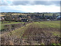
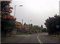
Hanwood, Shropshire
Hanwood viewed from a footpath north of the village.
Image: © Jeremy Bolwell
Taken: 16 Feb 2010
0.04 miles
6
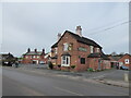
The Cock Inn, Hanwood in 2021
Closed at present of course.
Image: © Jeremy Bolwell
Taken: 17 Jan 2021
0.12 miles
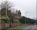
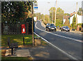
9
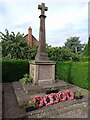
Hanwood war memorial
A red-granite base surmounted by a (Limestone?) cross, dedicated to 16 local men who fell in WW1, with a supplementary plaque naming a further 4 who were lost in WW2.
Image: © Richard Law
Taken: 27 Aug 2023
0.13 miles
10
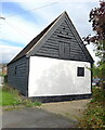
Former stables near The White House
Located effectively in the garden of Image, this is a set of late 17th century former stables and outbuildings at the farmhouse. It is timber framed behind the weatherboarding, and was Grade II listed https://britishlistedbuildings.co.uk/101176163-stables-approximately-20m-north-east-of-the-white-house-great-hanwood & https://historicengland.org.uk/listing/the-list/list-entry/1176163 in 1986.
Image: © Richard Law
Taken: 27 Aug 2023
0.13 miles