IMAGES TAKEN NEAR TO
Hanwood, SHREWSBURY, SY5 8LG
Introduction
This page details the photographs taken nearby to SY5 8LG by members of the Geograph project.
The Geograph project started in 2005 with the aim of publishing, organising and preserving representative images for every square kilometre of Great Britain, Ireland and the Isle of Man.

There are currently over 7.5m images from over14,400 individuals and you can help contribute to the project by visiting https://www.geograph.org.uk
Image Map
Images are licensed for reuse under creativecommons.org/licenses/by-sa/2.0
Notes
- Clicking on the map will re-center to the selected point.
- The higher the marker number, the further away the image location is from the centre of the postcode.
Image Listing (28 Images Found)
Images are licensed for reuse under creativecommons.org/licenses/by-sa/2.0
Image
Details
Distance
1
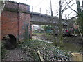
Railway bridge over the Rea Brook
Nice old bridge.
Image: © Jeremy Bolwell
Taken: 17 Jan 2021
0.01 miles
2

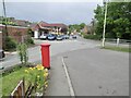
Old Milestone by the A488, Hanwood
Stone post (plate lost) by the A488, in parish of GREAT HANWOOD (SHREWSBURY AND ATCHAM District), Southwest of Rea Brook Bridge, by the road, on Northwest side of road. Minsterley stone, erected by the Shrewsbury to Minsterley turnpike trust in the 19th century.
Inscription once read:-
(Shrewsbury)
(4)
Milestone Society National ID: SA_SBBC04.
Image: © A Reade /J Higgins
Taken: 28 Jul 2008
0.04 miles
5

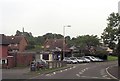
Former garage and filling station in Hanwood
Now trading as a 2nd-hand car business.
Image: © Richard Law
Taken: 27 Aug 2023
0.05 miles
6

Hanwood Bridge
The bridge dates from the early 19th century, and is constructed of roughly-coursed limestone & conglomerate blocks, with a limestone ashlar parapet on each side of the road. It was Grade II listed https://historicengland.org.uk/listing/the-list/list-entry/1055686 & https://britishlistedbuildings.co.uk/101055686-hanwood-bridge-great-hanwood in 1986.
Image: © Richard Law
Taken: 27 Aug 2023
0.07 miles
7
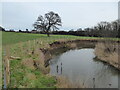
Part of the Rea Brook
Nice bank exposed there.
Image: © Jeremy Bolwell
Taken: 17 Jan 2021
0.07 miles
8

OS benchmark - Hanwood Bridge
An OS cutmark on one of the stone slabs forming the bridge parapet, which was last levelled by the OS in 1976 at 76.743m above Ordnance Datum Newlyn. It does however appear on the map of 1902 at 252.5ft Liverpool Datum.
Image: © Richard Law
Taken: 27 Aug 2023
0.08 miles
9

Hold up in Hanwood
On the A488 - a lorry a size too big for the low bridge under the railway ahead has stopped, and is having to reverse away.
Image: © David Long
Taken: 14 Feb 2006
0.08 miles
10
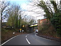
The railway bridge over the main road at Hanwood
One of those tricky ones...
Image: © Jeremy Bolwell
Taken: 6 Dec 2019
0.08 miles