IMAGES TAKEN NEAR TO
Lea Cross, SHREWSBURY, SY5 8HR
Introduction
This page details the photographs taken nearby to SY5 8HR by members of the Geograph project.
The Geograph project started in 2005 with the aim of publishing, organising and preserving representative images for every square kilometre of Great Britain, Ireland and the Isle of Man.

There are currently over 7.5m images from over14,400 individuals and you can help contribute to the project by visiting https://www.geograph.org.uk
Image Map (Loading...)


Getting Data...Please wait
Leaflet Map data © OpenStreetMap
Images are licensed for reuse under creativecommons.org/licenses/by-sa/2.0
Notes
- Clicking on the map will re-center to the selected point.
- The higher the marker number, the further away the image location is from the centre of the postcode.
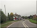
Image Listing (20 Images Found)
Images are licensed for reuse under creativecommons.org/licenses/by-sa/2.0
Image
Details
Distance
2
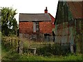
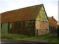
Grain store at Lea Cross
The building appears to have at least three generations of stone and brickwork.
Image: © John Barrett
Taken: 1 Jul 2006
0.03 miles
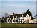
4
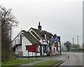
Lea Cross Tavern
The sign slanting down the wall above the single-storey wing is for the benefit of those who cannot stand up straight
Image: © David Smith
Taken: 29 Nov 2014
0.04 miles
5
Lea Cross Tandoori
Previously the Lea Cross Tavern and now a restaurant.
Image: © Jeremy Bolwell
Taken: 6 Dec 2019
0.04 miles
10
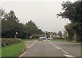
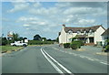
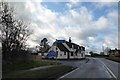
Bus stop and junction for Shorthill
From A488
Image: © John Firth
Taken: 26 Sep 2013
0.14 miles