IMAGES TAKEN NEAR TO
Castle Pulverbatch, Pulverbatch, SHREWSBURY, SY5 8DT
Introduction
This page details the photographs taken nearby to SY5 8DT by members of the Geograph project.
The Geograph project started in 2005 with the aim of publishing, organising and preserving representative images for every square kilometre of Great Britain, Ireland and the Isle of Man.

There are currently over 7.5m images from over14,400 individuals and you can help contribute to the project by visiting https://www.geograph.org.uk
Image Map (Loading...)


Getting Data...Please wait
Leaflet Map data © OpenStreetMap
Images are licensed for reuse under creativecommons.org/licenses/by-sa/2.0
Notes
- Clicking on the map will re-center to the selected point.
- The higher the marker number, the further away the image location is from the centre of the postcode.
Image Listing (31 Images Found)
Images are licensed for reuse under creativecommons.org/licenses/by-sa/2.0
Image
Details
Distance
1
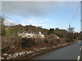
Cottages near Pulverbatch, Shropshire
A distinctive setting off the road and below the village.
Image: © Jeremy Bolwell
Taken: 13 Jan 2017
0.01 miles
2
The Knapp, Castle Pulverbatch, Shropshire
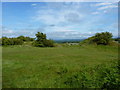
The motte and bailey site at Castle Pulverbatch, known as the Knapp, dates from the 11th century and was by the Normans, looking out for Welsh attack, as a strategic vantage point along the Shrewsbury- Bishop's Castle road . It is common land and over the years has been used for innumerable picnics, community gatherings and children's play. It is now classified by English Heritage as an ancient monument and nature reserve. There are excellent views of the Stretton Hills and the Wrekin.
Image: © Alison Gill
Taken: 16 Nov 2004
0.03 miles
3
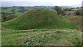
The Knapp at Pulverbatch
The Knapp is the local name for this Motte & Bailey structure just to the southwest of Pulverbatch. It's one of the best-preserved examples of its type in the country, and is thought to have been built in the 10th or 11th century AD. The motte is the conical mound in the background, which would have been topped by a stone or wooden tower, and surrounded by a fence. The bailey, or in this particular case, a double-bailey, is the embanked enclosure surrounding the motte, which protected a series of buildings associated with the motte tower.
Image: © Richard Law
Taken: 25 Jun 2011
0.07 miles
4
Motte at Castle Pulverbatch
https://historicengland.org.uk/listing/the-list/list-entry/1012860?section=official-list-entry
Image: © Sandy Gerrard
Taken: 29 Oct 2022
0.07 miles
5
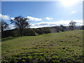
The Outer Bailey of The Knapp
The Knapp is the local name for this Motte & Bailey structure just to the southwest of Pulverbatch. It's one of the best-preserved examples of its type in the country, and is thought to have been built in the 10th or 11th century AD. The motte is the conical mound on the right, with an Inner Bailey (behind the hawthorn tree) to its left, and this much larger levelled bailey area outside that.
Image: © Richard Law
Taken: 25 Jun 2011
0.07 miles
6
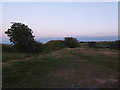
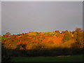
Castle Pulverbatch at dusk in summer
The Knapp or motte is visible here.
Image: © Jeremy Bolwell
Taken: 3 Jul 2018
0.07 miles
7
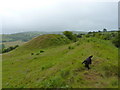
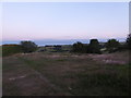
The old motte and bailey at Castle Pulverbatch
On a really sunny February morning.
Image: © Jeremy Bolwell
Taken: 27 Feb 2021
0.07 miles
8
Dusk at the motte in Castle Pulverbatch
A lovely, lonely, serene spot at such a time.
Image: © Jeremy Bolwell
Taken: 3 Jul 2018
0.08 miles
9
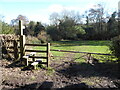
Stile on the footpath south of Pulverbatch
The fingerpost points our way today.
Image: © Jeremy Bolwell
Taken: 27 Feb 2021
0.08 miles
10
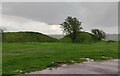
The motte at Castle Pulverbatch
The castle was probably built in the late 11th century but it had been abandoned by 1202. The motte still stands at over 20 feet high, surrounded by a deep ditch on two sides and earthworks.
Image: © Mat Fascione
Taken: 29 Apr 2023
0.08 miles