IMAGES TAKEN NEAR TO
Redhill Drive, SHREWSBURY, SY5 8BW
Introduction
This page details the photographs taken nearby to Redhill Drive, SY5 8BW by members of the Geograph project.
The Geograph project started in 2005 with the aim of publishing, organising and preserving representative images for every square kilometre of Great Britain, Ireland and the Isle of Man.

There are currently over 7.5m images from over14,400 individuals and you can help contribute to the project by visiting https://www.geograph.org.uk
Image Map (Loading...)


Getting Data...Please wait
Leaflet Map data © OpenStreetMap
Images are licensed for reuse under creativecommons.org/licenses/by-sa/2.0
Notes
- Clicking on the map will re-center to the selected point.
- The higher the marker number, the further away the image location is from the centre of the postcode.
Image Listing (17 Images Found)
Images are licensed for reuse under creativecommons.org/licenses/by-sa/2.0
Image
Details
Distance
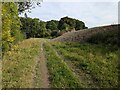
1

Access track and public footpath to Bayston Hill
Here the track crosses the Rea Brook.
Image: © TCExplorer
Taken: 19 Sep 2024
0.07 miles
2
Recently deposited materials on a field slope
On the right appears to be recently deposited material by the slope of a field.
Image: © TCExplorer
Taken: 19 Sep 2024
0.12 miles
3

Farmland between the A5 and Cambrian Line
Image: © N Chadwick
Taken: 18 Feb 2015
0.14 miles
4
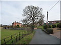
Farm on the outshirts of Hook-a-gate village near Shrewsbury
Elegant farm house and interesting outbuildings on the edge of the little village.
Image: © Jeremy Bolwell
Taken: 1 Dec 2011
0.16 miles
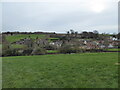
5
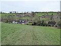
Looking down on Hook-a-gate village
Nice farms and buildings down there.
Image: © Jeremy Bolwell
Taken: 17 Jan 2021
0.17 miles
6
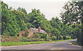
Site of Hookagate & Red Hill station, 1998
View NE on Longden Road approaching Nobold, towards Shrewsbury (Abbey) on the ex-Shropshire & Montgomeryshire Light Railway. The station - on the left - closed to passengers on 6/11/33 (goods 2/5/49), but the line was taken over by the War Department from 1/6/41, which ran a civilian service as well until it closed finally on 1/5/49. On the far side behind is the - still open - ex-GW&LNW Joint line, Shrewsbury - Buttington, connecting with the ex-Cambrian main line to Welshpool and the Welsh Coast.
Image: © Ben Brooksbank
Taken: 3 Jul 1998
0.17 miles
7
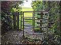
Gate on footpath from Hook-a-gate to Hanwood Bank
Image: © TCExplorer
Taken: 19 Sep 2024
0.19 miles
8
Looking down on Hook-a-gate village
Nice village with a mix of building styles.
Image: © Jeremy Bolwell
Taken: 17 Jan 2021
0.20 miles
9
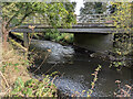
Bridge carrying the C5150 road over the Rea Brook
The road is classified as a C road and goes to Newton. The Rea Brook flows into Shrewsbury.
Image: © TCExplorer
Taken: 19 Sep 2024
0.20 miles
10

East along A5 near Nobold
Taken from layby on westbound A5. The bridge carries a minor road with a railway bridge behind
Image: © John Firth
Taken: 9 Nov 2010
0.20 miles