IMAGES TAKEN NEAR TO
Hookagate, SHREWSBURY, SY5 8BB
Introduction
This page details the photographs taken nearby to SY5 8BB by members of the Geograph project.
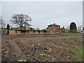
The Geograph project started in 2005 with the aim of publishing, organising and preserving representative images for every square kilometre of Great Britain, Ireland and the Isle of Man.

There are currently over 7.5m images from over14,400 individuals and you can help contribute to the project by visiting https://www.geograph.org.uk
Image Map (Loading...)


Getting Data...Please wait
Leaflet Map data © OpenStreetMap
Images are licensed for reuse under creativecommons.org/licenses/by-sa/2.0
Notes
- Clicking on the map will re-center to the selected point.
- The higher the marker number, the further away the image location is from the centre of the postcode.
Image Listing (10 Images Found)
Images are licensed for reuse under creativecommons.org/licenses/by-sa/2.0
Image
Details
Distance
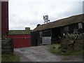
2
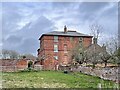
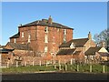
Whitley Grange
Substantial main building and surrounds
Image: © Andrew Shannon
Taken: 14 Apr 2022
0.14 miles
3
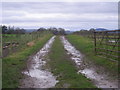
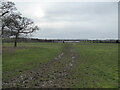
Footpath east from Whitley Grange
The Wrekin is in the distance.
Image: © Row17
Taken: 15 Jan 2008
0.16 miles
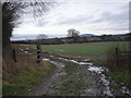
4
At Whitley Grange
The wife is having a manege constructed by the look of things. The stables are already in place. Nice.
Image: © Jeremy Bolwell
Taken: 17 Jan 2021
0.16 miles
5
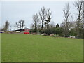
Rural view near Whitley Grange
Some big sheds in the distance.
Image: © Jeremy Bolwell
Taken: 17 Jan 2021
0.17 miles
6
Farm equipment at the field edge
Couple of ploughs etc.
Image: © Jeremy Bolwell
Taken: 17 Jan 2021
0.17 miles
8
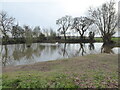
Pond in fields
With a pair of Swans.
Image: © Jeremy Bolwell
Taken: 17 Jan 2021
0.19 miles
9
Whitley Grange farm buildings & Mobile phone mast.
Image: © Row17
Taken: 15 Jan 2008
0.20 miles