IMAGES TAKEN NEAR TO
Annscroft, SHREWSBURY, SY5 8AW
Introduction
This page details the photographs taken nearby to SY5 8AW by members of the Geograph project.
The Geograph project started in 2005 with the aim of publishing, organising and preserving representative images for every square kilometre of Great Britain, Ireland and the Isle of Man.

There are currently over 7.5m images from over14,400 individuals and you can help contribute to the project by visiting https://www.geograph.org.uk
Image Map (Loading...)


Getting Data...Please wait
Leaflet Map data © OpenStreetMap
Images are licensed for reuse under creativecommons.org/licenses/by-sa/2.0
Notes
- Clicking on the map will re-center to the selected point.
- The higher the marker number, the further away the image location is from the centre of the postcode.
Image Listing (8 Images Found)
Images are licensed for reuse under creativecommons.org/licenses/by-sa/2.0
Image
Details
Distance
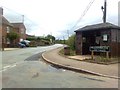

3
Annscroft
View to South-West in village of Annscroft
Image: © Andrew Bennett
Taken: 1 May 2007
0.21 miles
5
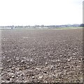
Still properly muddy
A ploughed field with a lot of stones suggesting alluvial action in the past. Between Longden and Annscroft.
Image: © Richard Webb
Taken: 19 Mar 2018
0.23 miles
6
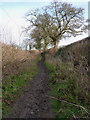
Properly muddy
This bridleway had recently seen the passage of a good number of horses, and apparently plenty of dogs too - judging by the footprints and 'calling cards' that some of them had left. I wondered if the local hunt had passed by earlier.
Image: © Richard Law
Taken: 28 Jan 2012
0.23 miles
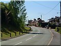
7
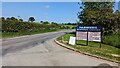
Entrance to the Farriers Business Centre
Image: © TCExplorer
Taken: 30 May 2023
0.23 miles
8
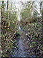
Properly wet
Not content with Image, the walk then became REALLY wet for a hundred yards, as this bridleway was effectively a stream.
Image: © Richard Law
Taken: 28 Jan 2012
0.24 miles