IMAGES TAKEN NEAR TO
Frodesley, Dorrington, SHREWSBURY, SY5 7NT
Introduction
This page details the photographs taken nearby to SY5 7NT by members of the Geograph project.
The Geograph project started in 2005 with the aim of publishing, organising and preserving representative images for every square kilometre of Great Britain, Ireland and the Isle of Man.

There are currently over 7.5m images from over14,400 individuals and you can help contribute to the project by visiting https://www.geograph.org.uk
Image Map
Images are licensed for reuse under creativecommons.org/licenses/by-sa/2.0
Notes
- Clicking on the map will re-center to the selected point.
- The higher the marker number, the further away the image location is from the centre of the postcode.
Image Listing (14 Images Found)
Images are licensed for reuse under creativecommons.org/licenses/by-sa/2.0
Image
Details
Distance
2
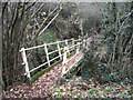
Footbridge beside the road
A little old.
Image: © Jeremy Bolwell
Taken: 10 Dec 2021
0.06 miles
3
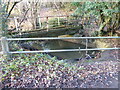
Footbridge over Row Brook
Old footbridge and footpath gate
Image: © Andrew Abbott
Taken: 14 Dec 2022
0.06 miles
4
Ford at Frodesley
This irish bridge ford is found at Rowbrook Farm close to the entrance to Stockback Granary on the Pitchford Estate. There is a footbridge beside the road in the trees.
Image: © John Walton
Taken: 8 Jun 2014
0.07 miles
8
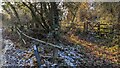
Field corner
Neglected and overlooked but important.
Image: © Jeremy Bolwell
Taken: 10 Dec 2021
0.17 miles
10
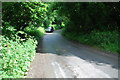
Drive to Rowe Farm
I like a nice long approach.
Image: © Jeremy Bolwell
Taken: 10 Dec 2021
0.19 miles